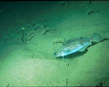
Hakes are among the many and varied species that live on the productive outer continental shelf off North Carolina.
Click image for larger view.
A Profile of The Point
Steve W. Ross, North Carolina National Estuarine Research Reserve
Kenneth J. Sulak, U.S. Geological Survey
Description
The U.S. East Coast continental slope, from Norfolk Canyon (off Virginia) south to Cape Lookout, NC, is an area of dramatic transition between the Middle Atlantic Bight province, with its major submarine canyons, and the South Atlantic Bight province of the Blake Plateau. The central part of this region, just north of Cape Hatteras, is unique hydrographically, (1) as the zone where the northward-flowing Gulf Stream meets the southward-flowing Virginia current, which together turni seaward, and (2) as the zone where the Gulf Stream crosses the underlying southward- flowing Western Boundary Undercurrent, resulting in an upper middle slope zone of little net motion. These characteristics produce highly productive conditions in the area.
The Hatteras slope around The Point harbors a unique, productive, and potentially fragile biological community as well as extremely important commercial and recreational fisheries. The area has the highest densities of benthic infauna anywhere along the U.S. East Coast continental slope, much higher organic carbon deposition rates than adjacent regions, an unusual concentration of benthic fishes and megafaunal invertebrates, and high levels of unusually rich suspended matter. The high productivity translates into an unusual concentration of large pelagic sportfishes, seabirds, and whales at or near the surface in the same area.

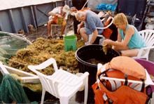
The tedious yet exciting task of sorting through Sargassum (seaweed) samples. Click image for larger view.
Mission Objectives
The mission objectives for this segment of the Islands in the Stream/South Atlantic Bight Expedition are to (1) document fish communities and habitats throughout the water column, and (2) define trophic/energetic pathways over the whole water column (surface to around 1,000 m).
We hypothesize that the unique surface and bottom faunas of The Point are interdependent (ecologically linked). If so, human perturbations of the bottom and midwater faunas may have significant impacts on pelagic fishes, seabirds, and marine mammals of economic and aesthetic importance. However, such an ecological coupling, which would be expressed by food-web interconnections among the nekton (fishes and large mobile invertebrates), has not yet been established. Nevertheless, dense concentrations of midwater fishes and squids observed near the bottom at depths of 400-800 m suggest upward cycling of organic matter as living prey for pelagic fishes. We hope to define these nekton faunal trophic linkages at The Point.
If our hypothesis is correct, we expect to find that foods eaten by fauna are derived from a variety of water-column locations. In particular, we intend to concentrate on the migrating mesopelagic community (squids, lanternfishes, etc.), which may be a major conduit between the bottom, the surface, and the aerial habitats. The null hypothesis is that the major sections of the water column are independent of each other (i.e., no trophic linkage) as would be demonstrated by diets that result from feeding only in one area. For example, bottom fishes would only feed on benthic prey, while surface fishes would only feed on surface prey. Knowing these trophic pathways, even for only one season, will allow significant insight into the flow of energy in this area, as well as the degree to which impacts may be translated to different communities. Such multi-habitat, multi-species, whole-system trophic studies are rare in marine ecology; therefore, this study is providing unique and useful data.
Habitats
Habitats to be examined include:
- sargassum - surface only
- water column
- sope canyons - mud bottoms with varying profiles (200-1,000 m).
Key Species (S=surface, M=midwater, B=bottom)
- Flying fishes - S
- Jacks - S
- Seabirds - S
- Filefishes - S
- Dolphin - S-M
- Tuna - S-M
- Whales - S-M
- Porpoises - S-M
- Lanternfishes B-S
- Hatchetfishes S-M
- Witch flounder – B
- Wolf eelpout - B
- Marlinspike - B
- Goosefish – B
- Hakes - B
- Blackbelly rosefish - B
- Squids - B-M
- Viperfishes - B-M
- Hagfish - B
- Sharks - S-B.
Protected Areas
The South Atlantic Fishery Management Council has designated the area of The Point as an Essential Fishery Habitat. This designation does not carry any special protection, however.
Interesting Facts
- The Point harbors some of the highest densities of benthic infauna anywhere along the U.S. East Coast continental slope.
- There are unusually high concentrations of benthic fishes and megafaunal invertebrates.
- It is one of the most productive recreational fishing areas on the East Coast for large species such as tuna, dolphin and billfish.
- The Point is hydrographically unique, being the only area along the U.S. East Cast where several major currents collide in such a complicated way.
- It is an extremely rich area for marine mammals and seabirds due to high water-column productivity.
Sign up for the Ocean Explorer E-mail Update List.


