The Wimble Shoals project team sought to complete a detailed magnetic survey of the shoal, coinciding with the deployment of a high-resolution side scan sonar. A primary goal was to identify and characterize cultural resources of the shoal.
The collected information will be compared to preexisting baseline datasets from federal government (U.S. Geological Survey, U.S. Army Corps of Engineers), private (Geodynamics, LLC), and East Carolina University sources. These datasets, while an important foundation upon which to build an understanding of the shoal, are not of sufficient resolution to assist with the discovery and classification of cultural resources in the area.
The primary archaeological devices were a Geometrics G882 magnetometer and a Klein 3000H side scan sonar. A survey area 10 kilometers wide and 10 kilometers long (~6 by 6 miles) was selected to cover the outer extent of Wimble Shoals (i.e., portions of the shoal outside of State waters) and to incorporate other reported shipwreck locations (including multiple reported locations of Mirlo). Within this area, the scientific team sought to initially cover 100 survey lines, spaced at 100-meter (328-foot) intervals.

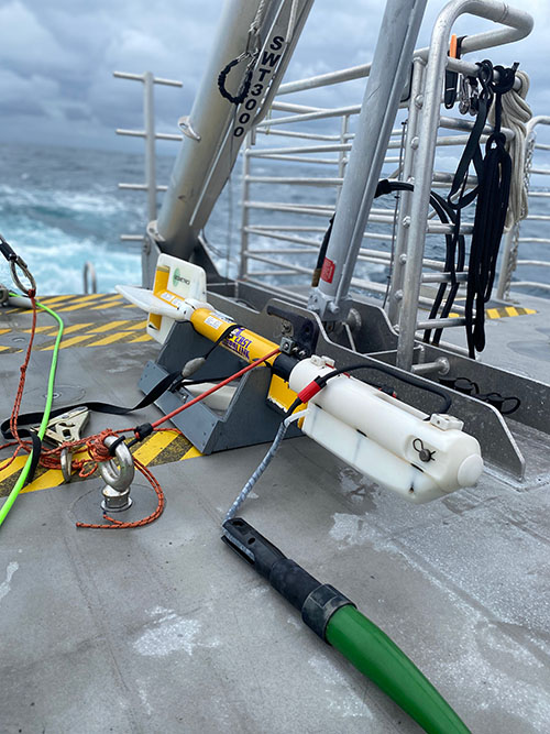
The Geometrics G882 magnetometer on the back deck of Research Vessel Shearwater awaiting deployment. Image courtesy of Wimble Shoals: An Exploration and Characterization of Submerged Cultural and Sediment Resources. Download larger version (jpg, 5.5 MB).
Within the context of a submerged and potentially migrating shoal (i.e., with the potential to bury shipwrecks), the magnetometer served a critical need for identifying sub-seabed cultural materials. With the G882’s high sensitivity (0.1nanoteslas), it is able to detect ferromagnetic material from objects much smaller than the very large steel-hulled shipwrecks believed to be within the search area. Examining magnetic anomalies and acoustic data together allows for comprehensive target identification.

Dr. Nathan Richards, director of East Carolina University’s Program in Maritime Studies, processing data collected using the side scan sonar. Image courtesy of Wimble Shoals: An Exploration and Characterization of Submerged Cultural and Sediment Resources. Download larger version (jpg, 3.8 MB).
Initial lower-resolution remote sensing data will be processed and a list of prioritized targets will be compiled. After ranking targets, areas of suspected submerged cultural remains will be revisited for recording at higher resolutions and more detailed recording.