
By Dr. Peter Etnoyer, Chief Scientist
August 31, 2017
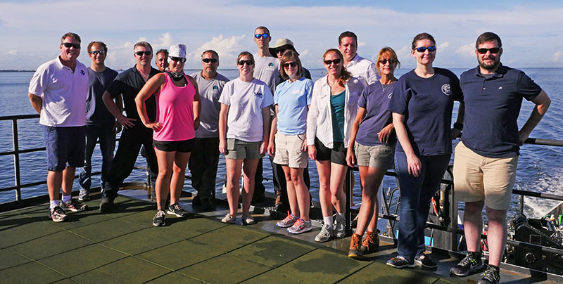
Team photo for the expedition, from left to right—Peter Etnoyer, Daniel Wagner, Jesse Doren, Paul Sanacore, Tracy Sorgenfrei, Kris Ingram, Stacey Harter, Jonathan Gallant, Erik Hodges, Katharine Coykendall, Heather Coleman, John Gray, Sandra Brooke, Morgan Kilgour, and Matt Poti. Image courtesy of Ralf Meyer, Green Fire Productions. Download larger version (jpg, 6.1 MB).
NOAA Ship Nancy Foster docked in St. Petersburg on August 24, culminating Leg 1 of the 2017 Southeast Deep Coral Initiative (SEDCI) expedition. The team members gathered for a photo before going their separate ways. The deck crew off-loaded the remotely operated vehicle (ROV) Odysseus. Scientists organized data and packed samples. The ship’s crew prepared for the next leg, restocking stores and performing maintenance.
As Chief Scientist, one of my responsibilities is to summarize the expedition as a way to wrap things up before the work ahead begins. My favorite task is to gather a few key statistics. I also like to take a selfie with the robot. It’s my tradition. These robots are like friends; we share struggles and victories.
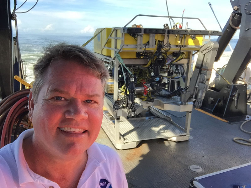
Chief Scientist Dr. Peter Etnoyer of NOAA takes a selfie with the ROV Odysseus. Image courtesy of Peter Etnoyer, NOAA National Centers for Coastal Ocean Science. Download larger version (jpg, 712 KB).
The primary objectives of the expedition were to map new areas, conduct visual surveys with the ROV, and collect biological samples. The goal of the work was to provide new information about areas that are under consideration for protection. These goals and objectives were accomplished.
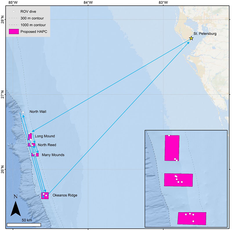
Map showing the areas of exploration for the Southeast Deep Coral Initiative (SEDCI) expedition aboard NOAA Ship Nancy Foster, cruise number NF1708. Image courtesy of Daniel Wagner, NOAA National Centers for Coastal Ocean Science; JHT Inc. Download larger version (jpg, 408 KB).
The SEDCI 2017 expedition made 13 successful dives over 10 working days, thanks to good weather. Total bottom time was 51.5 hours. The sea state was calm but surface currents were strong. The team explored four out of five target sites, including Long Mound, North Reed Site, Many Mounds, and Okeanos Ridge. Pulley Ridge was dropped due to weather. A new site was added called ‘Wall in the North,’ where we had an unexpected encounter with a swordfish.
New, high-resolution seafloor maps were generated for close to 2,300 square meters, including 1,965 square meters that had never been mapped before, about the size of 22 football fields. The maps showed a long linear feature in the 200-250 meter depth range that should be explored in the future. It was parallel to the other deeper ridge.
Many types of samples were collected – images, water, biological, and rocks. A total of 59 water samples were collected for carbonate chemistry. The CTD rosette was deployed 17 times in the vicinity of deep coral reefs, mostly to 400-500 meters depth, but as deep as 1,000 meters. The number of biological samples collected was 51. Of those, 14 corals were maintained alive, including a rare orange Lophelia pertusa color variant. These live cultures will provide important information on growth and reproduction. Other samples will be used for studies on taxonomy, genetics, age, and growth. Images will provide site characterization information for the Gulf of Mexico Fishery Management Council and others who have the responsibility of managing deep-sea resources. In some cases, our photographs add a dimension to existing sets of coral community photographs taken at various points through time. In others, they shed new light on previously unexplored sites of interest to the Council.
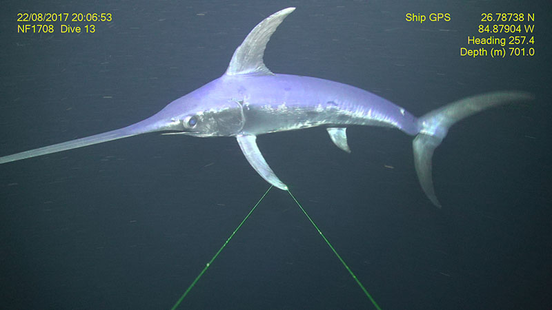
A swordfish Xiphius gladius at the ‘Wall in the North’ dive site southwest of Tampa, Florida. Image courtesy of NOAA Southeast Deep Coral Initiative and Pelagic Research Services. Download larger version (jpg, 1.2 MB).
The challenges for the ship and ROV were primarily related to the strength of the surface currents ripping at 2-3 knots for most of the time. Strong ‘loop’ currents required the ship to move south on every dive, as this was the only direction we could go. To complicate things, navigation beacons failed, so the team flew by dead reckoning, using maps and sonar to guide direction, and relying on depth and tether length to guess our position. This all worked out, fortunately. We just had to be flexible.

A tinselfish swims among Lophelia thickets at Okeanos Ridge on the West Florida slope. Tinselfish (Family Grammicolepididae) were one of the more commonly observed fish species around 500 meters depth. Image courtesy of NOAA Southeast Deep Coral Initiative and Pelagic Research Services. Download larger version (jpg, 1.3 MB).
A key outcome of our surveys was that we found more coral in more places than expected. At North Reed site, Lophelia pertusa was relatively abundant, even in some ‘flat’ areas. Backscatter mapping data showed large mound features, but not the corals between them. Likewise, along the ridges we surveyed at Many Mounds and Wall in the North, hundreds of black corals were observed over large distances. Colonies were sparse but nearly constant along the survey track. Large aggregations of Lophelia were found at Okeanos Ridge for the first time, on a sloping wall where they were not expected. We also observed evidence of lost or abandoned fishing gear, sometimes in association with corals and sponges.
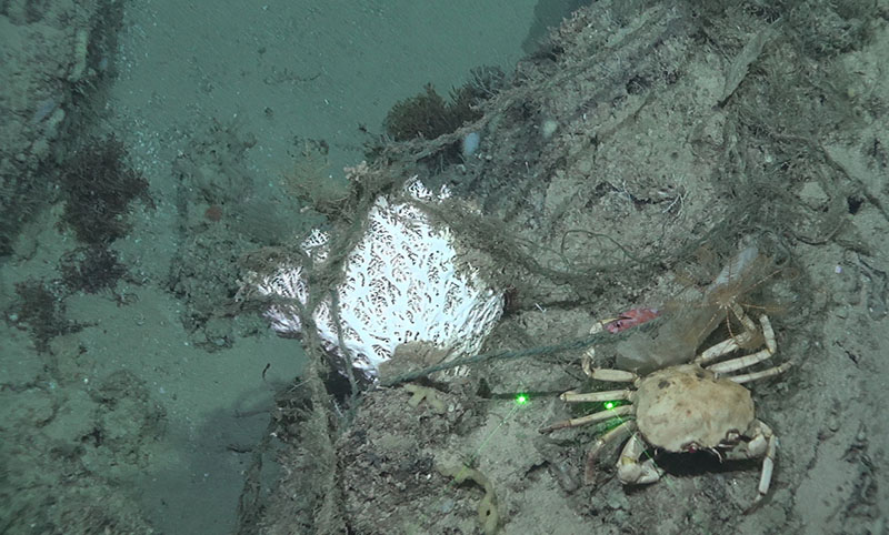
Lace coral entangled with discarded line at North Reed Site on the West Florida Slope at approximately 400 meters depth. A golden crab, blackbelly rosefish, and crinoid are also visible to the right of the coral. Image courtesy of NOAA Southeast Deep Coral Initiative and Pelagic Research Services. Download larger version (jpg, 1.2 MB).
The combined results suggest finer-resolution maps (on the scale of 1-2 meters) and more ROV dives will be needed to estimate the full extent of thesecorals within our study areas, including places where corals may not be expected. Many observations were made and will continue to come (including coral genetics and reproduction information), thanks to the dedicated efforts of our ROV, ship, science, and documentary teams, yet much more of the eastern Gulf of Mexico seafloor remains to be explored.
The expedition is supported by NOAA’s Deep Sea Coral Research and Technology Program through the Southeast Deep Coral Initiative (SEDCI), a multi-disciplinary effort that will study deep-sea coral ecosystems across the Southeast United States in 2016-2019.