August 2 - September 14, 2010
The 2010 Extended Continental Shelf survey was a 5-week-long expedition involving two icebreakers: U.S. Coast Guard cutter (USCGC) Healy (at sea August 2 to September 6) and the Canadian Coast Guard ship (CCGS) Louis S. St-Laurent (at sea August 4 to September 14).
This was the sixth in a series of U.S. cruises to the Arctic Ocean and the third in which U.S. and Canadian scientists are working together to map areas of the seafloor and to image the underlying sediment layers. The data was used to determine the limits of the “extended continental shelf.” Previous joint missions were conducted in 2008 and 2009.
Under international law, as reflected in the U.N. Convention on the Law of the Sea, every coastal country has a continental shelf out to 200 nautical miles (nm) from its coastal baselines, or to a maritime boundary with another coastal country. However, the continental shelf of a coastal country extends beyond 200 nm (and is called, therefore, the “extended continental shelf”) if it meets criteria outlined in Article 76 of the Convention. (Note that this legal definition of continental shelf is different from that traditionally used by marine geologists.)
Planned tracklines for the 2010 U.S.-Canada Extended Continental Shelf survey. "EEZ" stands for Exclusive Economic Zone, which extends from a nation's coastline out 200 nautical miles (or to a maritime boundary with another nation). nm, nautical miles; km, kilometers. Image courtesy of USGS. Download image (jpg, 227 KB).
The 2010 survey is taking place primarily in the Canada Basin of the Arctic Ocean, in an area bounded approximately by latitudes 71°N to 85°N and longitudes 158°W to 112°W (see trackline map above). This will be the first joint expedition to image sub-seafloor sediment layers within 200 nautical miles (nm) of the coast in the Arctic Ocean.
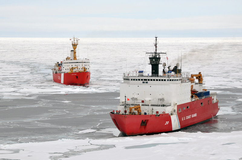
The 2010 survey is a two-ship expedition. The primary goal is to collect both multichannel seismic data (which will be done by explorers aboard the Louis S. St-Laurent) and multibeam echosounder data (handled by those aboard the Healy). In light to moderate ice, the Healy leads and breaks ice so that the Louis can tow its seismic gear. Where heavy ice makes towing the seismic equipment unsafe, or in areas where multibeam bathymetric (water depth) data have scientific priority, the Louis breaks ice ahead of the Healy.

The U.S. Coast Guard cutter Healy (in the foreground) and Canadian Coast Guard cutter Louis S. St. Laurent working together. Image courtesy of USGS. Download larger version (jpg, 4.8 MB).
In locations where open water permits, the two ships can operate independently. At these times, the Healy may also collect samples of the seafloor, using a variety of devices. A rock dredge, for example, collects samples of bedrock from the sloping sides of bathymetric features. Additional sampling may include dart coring of rock outcrop, and piston coring, box coring, gravity coring, or dredge sampling of abyssal — depths between 2,000 and 6, 000 meters (6,560 and 19,680 feet) — seafloor material. Information from these samples helps to define the limits of the extended continental shelf as well as to expand our knowledge of the region's geologic history.

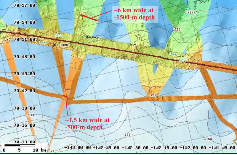
The two ships use a multibeam echosounder to map swaths of seafloor, which is then compiled to the onboard Map Server. Image courtesy of Helen Gibbons, USGS/ECS Project. Download larger version (jpg, 857 KB).
The surveying systems on both ships rely on acoustic (sound) signals that bounce off surfaces, separating materials of different acoustic impedance — the product of the speed of sound in the material multiplied by its density. Examples of such surfaces are the boundary between water and sediment (the seafloor) and the boundaries between rock or sediment layers of different types. The frequency and energy of the acoustic signals, produced by sound sources (either mounted on or towed behind the vessel), determine how deeply the sound will penetrate beneath the seafloor and how much resolution (detail) will be revealed in the resulting images. Higher frequencies provide greater resolution but less penetration below the sea floor; lower frequencies yield deeper penetration but less resolution.
New to this year's project is a subsidiary study of ocean acidification, in which seawater samples are being collected and analyzed to examine the effect of increasing levels of atmospheric CO2 on arctic waters. As in previous years, ice extent and characteristics are being recorded, and (as conditions permit) open-ocean and ice buoys are being deployed to track water currents and ice movement.
Marine mammal observers are also aboard, recording mammal sightings in areas where observations are rarely made and alerting the ship's officers when a mammal is close enough that operations should be adjusted in order to avoid disturbing it.
The U.S. part of the mission is being led by the U.S. Geological Survey (USGS), with additional funding and scientific support from the U.S. Coast Guard. Dr. Brian Edwards, USGS, is chief scientist of the expedition aboard the Healy. Dr. David Mosher of Natural Resources Canada, Geological Survey of Canada, is leading the Canadian part of the mission. Jonathan Childs of the USGS is the U.S. liaison aboard the Louis and head of the U.S. Interagency Task Force Seismic Data Operations Team.
This collaboration offers many benefits. It continues to save millions of dollars for both countries, provide data both countries need, ensure that data are collected only once in the same area, and increase scientific and diplomatic cooperation. Expectations are that the two nations will work together again in the summer of 2011.