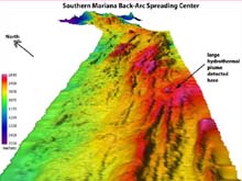
A three-dimensional view of the southern Mariana back-arc spreading center, where hydrothermal activity was detected during a CTD tow-yo. Click image for larger view.
In Search of Hydrothermal Plumes
February 12, 2003
Susan Merle
Geological Research Assistant
Vents Program, Pacific Marine Environmental Laboratory, NOAA
One of our principal tasks on this phase of the “Submarine Ring of Fire” project is to discover which of the many arc volcanoes we are mapping also host active hydrothermal fields, legacies of past eruptions, on their summits. We explore for these fields by searching for the hydrothermal plumes that float below us, hidden by a mile of opaque sea. As the hot vent fluids rise into the water column, they are diluted by the surrounding seawater and coalesce into a wispy cloud of chemicals and mineral grains carried away by the local currents. We use two types of operations to locate and sample these plumes. The simplest one is called a vertical cast. The ship holds position over a location on the sea floor, and the instrument is slowly lowered down through the water column to within a few meters of the bottom.

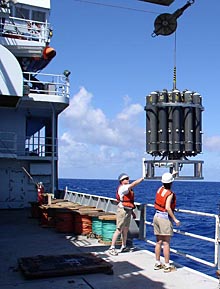
Geoff Lebon and Stacy Maenner launch the CTD over the side of the research vessel Thomas G. Thompson. Click image for larger view.
The principal instrument package is called a "CTD." This acronym stands for "conductivity (an indication of seawater salinity, temperature, depth" for the primary data that is measured. Another instrument measures the turbidity of the water, which estimates the concentration of particulate matter suspended in the plumes. The CTD also carries 21 special plastic bottles that hold 19-liter sewater samples. At the end of the cast, when the CTD is returned to the ship's deck, scientists on board take samples from each bottle to analyze for a variety of chemicals added to the water by hydrothermal venting.
The second operation, called a tow-yo, uses the same equipment as the vertical cast. Instead of the ship holding a position, during a tow-yo it slowly moves through the water at a speed of about 1.5 knots. While the ship is moving we use a winch to raise and lower the CTD, so that its path above the sea floor traces a "sawtooth" pattern. This technique allows us to obtain more detailed information about the distribution of hydrothermal plumes over a wide area.

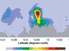
The location of hydrothermal vent fields can be estimated by mapping the distribution of particle plumes (measured in units of NTU) over the ridge. The most intense plumes, seen here as yellow, red and brown colors, were observed over the shallowest portion of the ridge. Click image for larger view.
We used a single tow-yo operation lasting more than 24 hrs to map hydrothermal plumes over the portion of the Mariana back-arc spreading center shown in the back-arc plume figure at right. The figure shows the relative concentration of suspended mineral grains in the water. These grains were formed as the hot vent fluids were diluted and cooled upon mixing with seawater. The results indicate that a major vent field is active near 12.95 degrees N, where the ridge is shallowest. Minor vent fields are likely present near 12.75 degrees N and between 13.1 and 13.2 degrees N, the locations of weaker and deeper plumes. The broad but weak plume near 12.8 degrees N is probably a remnant of the major plume, carried south by the local currents.
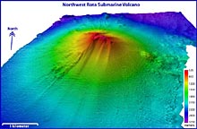
After leaving the back-arc spreading center, we came northeast to begin exploring the island arc volcanoes lying west of the Mariana Trench. Since most of these edifices have the classic conical shape of volcanoes on land, one or two vertical CTD casts were sufficient to check for activity. Last night, we found our first hydrothermally active arc volcano, lying about 40 mi northwest of the island of Rota. The venting was streaming into the ocean from the top of the volcano at a depth of 500 m.

A three-dimensional view of northwest Rota submarine volcano, where hydrothermal activity was detected during a CTD cast. Click image for larger view.
Although everyone was very excited to find this site, we were left with more questions than answers. For example, why does this volcano have an active hydrothermal system when several very similar volcanoes to the south do not? To answer this and other questions, we are eager to find more active systems as we move north along the Mariana Arc.


