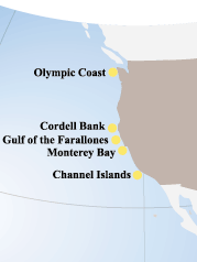
Map of the west coast National Marine Sanctuaries.
The National Marine Sanctuaries
In 1972, exactly one hundred years after the first national park was created, the nation made a similar commitment to preserving its marine treasures by establishing the National Marine Sanctuary Program. Since then, thirteen national marine sanctuaries, representing a wide variety of ocean environments, have been designated.
Five of the west coast national marine sanctuaries are taking part in Sanctuary Quest. Below is more information about each.
Channel Islands NMS
The waters that swirl around the five islands within the Channel Islands National Marine Sanctuary combine warm and cool currents to create an exceptional breeding ground for many species of plants and animals. Forests of giant kelp are home to numerous populations of fish and invertebrates. Every year more than 27 species of whales and dolphins visit or inhabit the sanctuary including the rare blue, humpback and sei whales. On the islands, seabird colonies and pinniped rookeries flourish while overhead brown pelicans and Western gulls search the water for food. Learn more about the Channel Islands National Marine Sanctuary ![]() here.
here.
Monterey Bay NMS
The waters of Monterey Bay and the adjacent Pacific Ocean off the central California coast were designated and protected in 1992 as the Monterey Bay National Marine Sanctuary. This vast area stretches 400 miles (348 nautical miles) north to south, extends an average of 35 miles (30 nautical miles) offshore, and covers over 5300 square miles (4,024 square nautical miles). The sanctuary is managed to balance recreational and commercial uses with protection of natural resources, water quality, habitats, and its bountiful resident and migratory marine life. Learn more about the Monterey Bay National Marine Sanctuary ![]() here.
here.
Gulf of the Farallones NMS
Just north and west of San Francisco Bay a large expanse of Pacific Ocean along with nearshore tidal flats, rocky intertidal areas, wetlands, subtidal reefs, and coastal beaches were designated in 1981 as Gulf of the Farallones National Marine Sanctuary. This 1,255 square mile area (948 square nautical miles) is larger than the state of Rhode Island. The Farallon Islands, 30 miles (26 nautical miles) west of the Golden Gate Bridge in the south central part of the sanctuary, are a national wildlife refuge, offering resting and breeding sites for marine mammals and seabirds, lured by nutrient-rich waters. The sanctuary has thousands of seals and sea lions, and is home to the largest concentration of breeding seabirds in the continental United States. Learn more about the Gulf of the Farallones National Marine Sanctuary ![]() here.
here.
Cordell Bank NMS
About 52 miles (45 nautical miles) northwest of the Golden Gate Bridge, at the edge of the continental shelf, Cordell Bank rises from the seafloor. Over most of it, the water is about 200 feet deep. Along a few of its ridges and pinnacles, this submerged island rises to within 120 feet of the ocean surface. Here, upwellings of nutrient rich ocean waters and the bank's topography create one of the most biologically productive areas on the West Coast.
The site is a lush feeding ground for many marine mammals and seabirds. Algae and invertebrates proliferate. Endangered humpback whales along with Dall's porpoises, albatross, shearwaters, and countless other marine species flourish in this extraordinarily rich marine environment. However, few people have seen this special part of the California seafloor due to its depth, currents, and distance from the mainland.
The significant value of this marine habitat was officially recognized in 1989 when 526 square miles (397 square nautical miles) of Pacific Ocean including and surrounding Cordell Bank were designated as a national marine sanctuary.
Olympic Coast NMS
The Olympic Coast National Marine Sanctuary covers over 3300 square miles (2500 square nautical miles) of ocean waters off Washington State's rugged and rocky Olympic Peninsula coastline. Sanctuary waters extend an average of 35 miles (30 nautical miles) offshore and span 135 miles (117 nautical miles) north to south, stretching from United States/Canada international boundary to the Copalis River. The sanctuary provides habitat for one of the most diverse marine mammal faunas in North America, and is a critical link in the Pacific flyway. Designated as a national marine sanctuary in 1994, the site is managed to protect its natural resources while encouraging compatible commercial and recreational uses. Major resource management issues include vessel traffic, spill prevention and response, water quality, and the ecological impact of fishing.
Visitors will find a spectacular, sparsely populated, and undeveloped shoreline for nearly the entire length of the sanctuary. Forty-eight miles of the sanctuary are adjacent to wilderness beaches of the Olympic National Park. The Washington Maritime National Wildlife Refuge encompasses the rocks, islets, and islands that rise above mean high tide in sanctuary waters. Several reservations along the shoreline preserve the culture of the Quinault, Hoh, Quileute, and Makah tribes. Learn more about the Olympic Coast National Marine Sanctuary ![]() here.
here.
Sign up for the Ocean Explorer E-mail Update List.


