2023 Seascape Alaska Expeditions (EX2302-EX2307)
May 2023 - September 2023
From May through September 2023, NOAA and partners conducted a series of telepresence-enabled ocean exploration expeditions on NOAA Ship Okeanos Explorer to improve knowledge about unexplored and poorly understood deepwater areas offshore Alaska, with a particular focus on the Aleutian Islands, Gulf of Alaska, and Aleutian Trench.
Data collected during the Alaska expeditions will establish a baseline in explored areas to catalyze further exploration, research, and management activities. Data will also contribute to Seascape Alaska, a regional campaign aimed at fully mapping U.S. waters off Alaska, creating accessible, high-quality modern seabed data for Alaskan waters to support U.S. research, resource management, sustainable economic growth, and the health and security of Americans.
View a summary of NOAA Ocean Exploration 2023 Seascape Alaska expeditions.
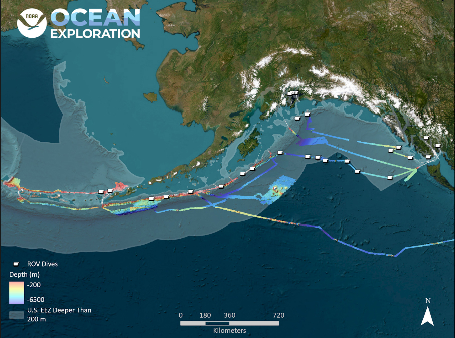
The six telepresence-enabled expeditions offshore Alaska in 2023 included remotely operated vehicle (ROV) dives and multibeam sonar mapping operations. Expedition dates, numbers and names, operational modes, and ports of call were as follows:
May 5 - 26: EX2302: Seascape Alaska 1: Aleutians Deepwater Mapping / Seattle, Washington - Dutch Harbor, Alaska
June 5 - 20: EX2303: Seascape Alaska 2: Aleutians Deepwater Mapping / Dutch Harbor, Alaska to Kodiak, Alaska
July 14 - July 25: EX2304: Seascape Alaska 3: Aleutians Remotely Operated Vehicle Exploration and Mapping / Kodiak, Alaska to Dutch Harbor, Alaska
August 1 - 17: EX2305: Seascape Alaska 4: Gulf of Alaska Deepwater Mapping / Dutch Harbor, Alaska to Kodiak, Alaska
August 23 - September 16: EX2306: Seascape Alaska 5: Gulf of Alaska Remotely Operated Vehicle Exploration and Mapping / Kodiak, Alaska to Seward, Alaska
September 23 - October 14: Seascape Alaska 6: Gulf of Alaska Transit Mapping / Seward, Alaska to San Francisco, California
Summary: NOAA Ocean Exploration Seascape Alaska Expeditions
Despite contributing the largest area to the U.S. Exclusive Economic Zone, Alaskan waters remain one of the least explored areas in the United States. Current mapping data for the waters around Alaska address only 34% of the seafloor, and much the available data are sparse and predate modern mapping technologies. Additionally, most deepwater habitats in Alaskan waters remain predominantly unexplored.
To address these gaps, from May through September 2023, NOAA and partners conducted the Seascape Alaska series of telepresence-enabled ocean exploration expeditions on NOAA Ship Okeanos Explorer. Through mapping operations, remotely operated vehicle (ROV) dives, and autonomous underwater vehicle operations, we were able to collect data to improve knowledge about unexplored and poorly understood deepwater areas offshore Alaska, with a particular focus on the Aleutian Islands, Gulf of Alaska, and Aleutian Trench.
Download a PDF version of the Seascape Alaska expeditions summary (1.7 MB).
From May through September 2023, NOAA and partners conducted a series of remotely operated vehicle and mapping expeditions onboard NOAA Ship Okeanos Explorer to improve knowledge about unexplored and poorly understood deepwater areas offshore Alaska. Partnerships were key to the success of these expeditions and took form in a variety of manners, from community input on dive sites to the creation of the first annual Seward Science Symposium, which provided a venue for the exchange of ideas, setting the stage for collaborations far into the future. Data collected during the Alaska expeditions contributed to the establishment of a baseline of understanding of these areas and served to catalyze further exploration, research, and management activities. This data also contributed to Seascape Alaska, a regional campaign aimed at fully mapping U.S. waters off Alaska by 2040, creating accessible, high-quality modern seabed data for Alaskan waters to support U.S. research, resource management, sustainable economic growth, and the health and security of Americans. Video courtesy of NOAA Ocean Exploration, Seascape Alaska. Download largest version (mp4, 728 MB)
Science Themes
- Acquire data to support science and management needs
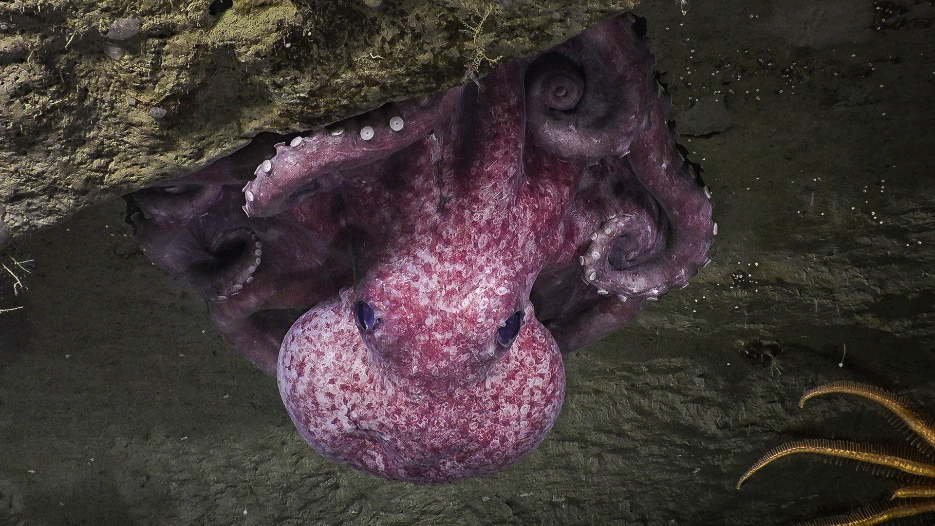
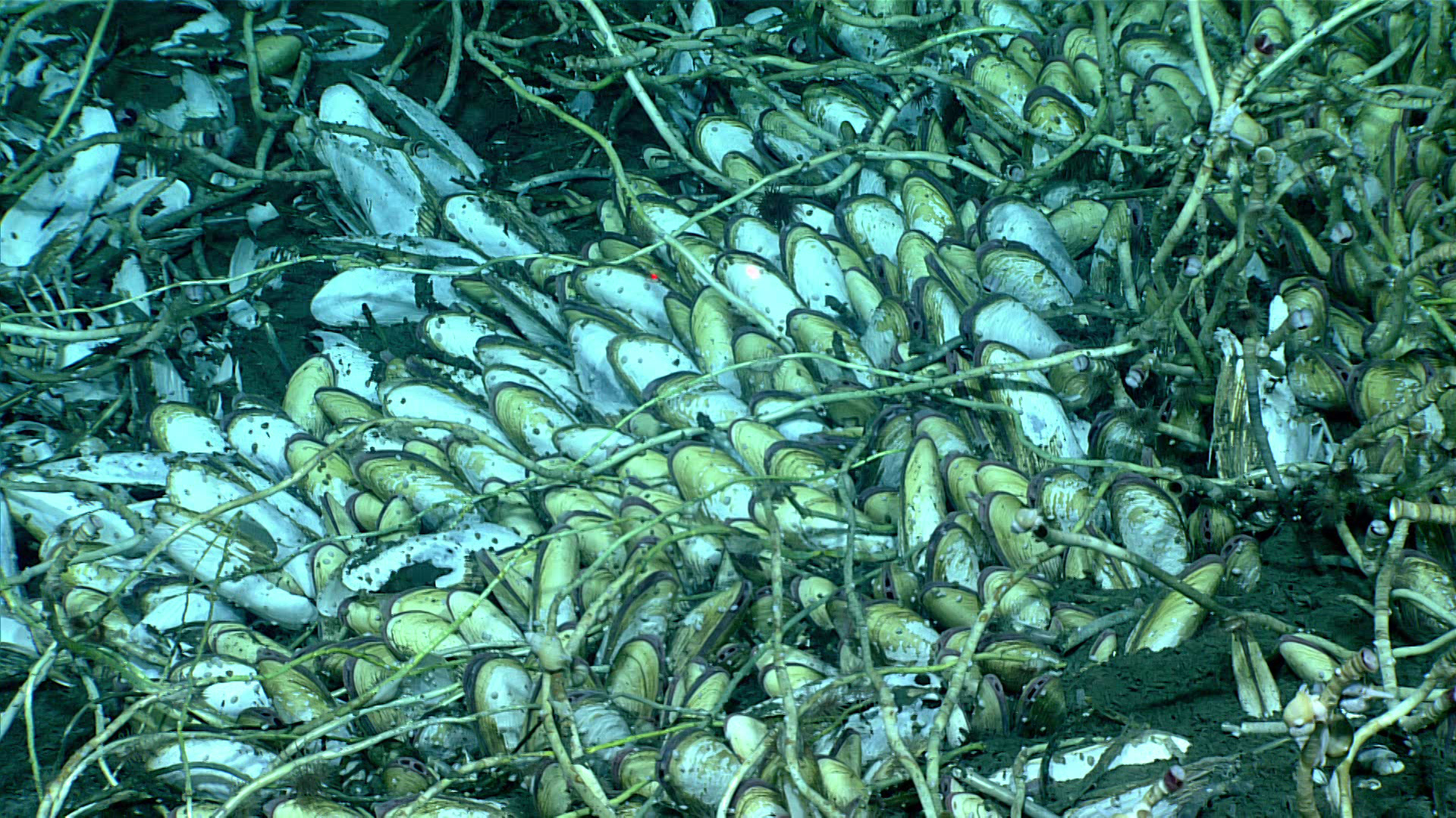
- Identify and map vulnerable marine habitats, particularly high-density, deep-sea coral and sponge and cold-seep communities
- Investigate the geologic history of the Aleutian Arc, including potential relevance to plate tectonics, geohazards, and subduction zone biology and geology
- Increase understanding of deep-sea biogeographic patterns across the North Pacific
Summary Highlights
- Over 285,000 square kilometers (110,040 square miles) of seafloor mapped
- 27 ROV dives at a depth range of 250 - 4,300 meters (820 - 14,110 feet)
- 94 primary biological and 38 geological samples collected
- Over 150 participating scientists, students, and managers
- Nearly 300,000 live video views
NOAA and partners initiated the Seascape Alaska series of six expeditions aboard NOAA Ship Okeanos Explorer, using a dual-body remotely operated vehicle (ROV) capable of collecting biological and geological samples and diving to 6,000-meter depths and 4 different types of mapping sonars to explore deep waters in and around the Aleutian Islands, the Gulf of Alaska, the Alexander Archipelago, Prince William Sound, and the high seas. Additional acoustic mapping data were collected by partners on Research Vessel Kilo Moana over the Patton Seamount Chain.
Scientists, resource managers, and students located on shore actively participated in the expeditions, thanks to telepresence technology on Okeanos Explorer. That same technology allowed us to host ship-to-shore live interactions and deliver live online streaming of ROV dives to the general public, opening a window of understanding into the deep waters off Alaska for audiences around the world.
Data collected during these expeditions will help to establish a baseline in explored areas and spur further exploration, research, and management activities. Data will also contribute to the National Strategy for Exploring, Mapping, and Characterizing the United States Exclusive Economic Zone, Seabed 2030, and the broader Seascape Alaska campaign aimed at fully mapping U.S. waters off Alaska.

Education Themes


Media Resources
Media Contacts
Emily Crum
Communication Specialist
NOAA Ocean Exploration
ocean-explore-comms@noaa.gov
Keeley Belva
Public Affairs Officer
NOAA Office of Marine and Aviation Operations
keeley.belva@noaa.gov
NOAA Ocean Exploration’s 2023 Seascape Alaska expeditions will contribute to the National Strategy for Exploring, Mapping, and Characterizing the United States Exclusive Economic Zone, Seabed 2030, and multipartner Seascape Alaska campaign, which has been endorsed by the Intergovernmental Oceanographic Commission of UNESCO as part of the United Nations Decade of Ocean Science for Sustainable Development 2021-2030.
Data collected during all expeditions will be available in NOAA’s public data archives within 90-120 days of its completion and will be accessible via the NOAA Ocean Exploration Data Atlas.