By
Rachel Gulbraa, Engagement Specialist, NOAA Ocean Exploration
Mike White, Physical Scientist/Expedition Coordinator (ROV), NOAA Ocean Exploration
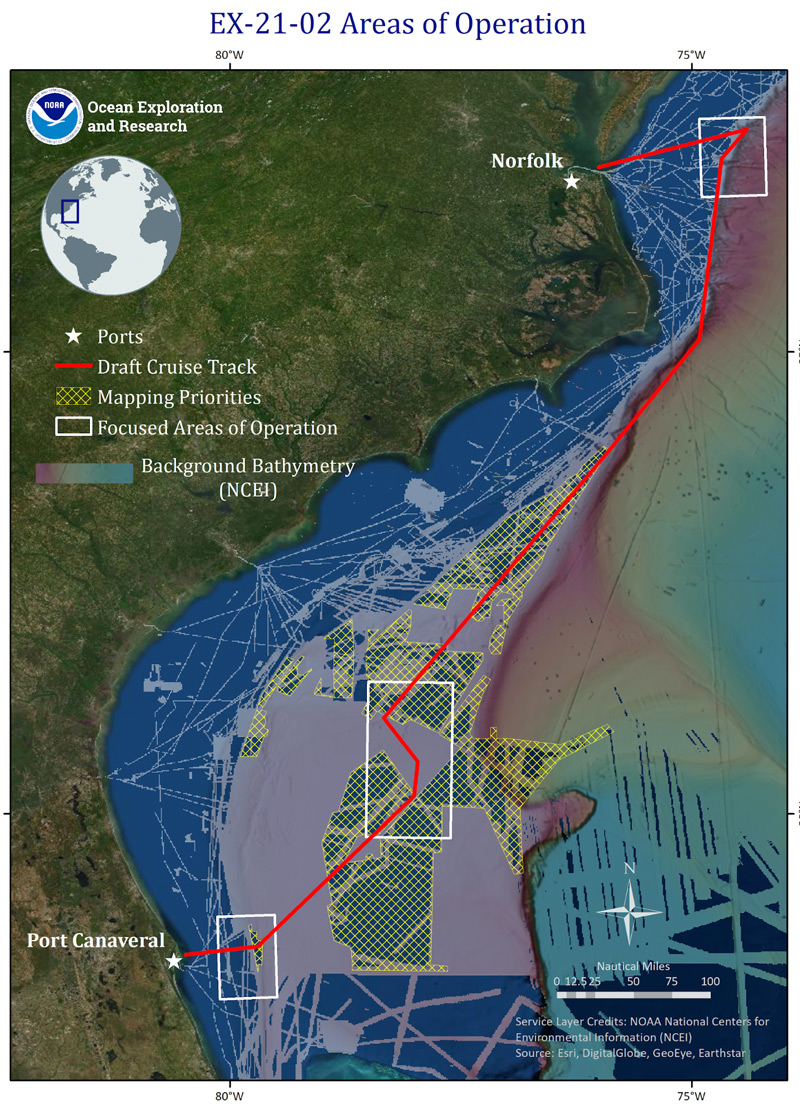
From May 14-27, 2021, NOAA Ocean Exploration will lead the 2021 Technology Demonstration on NOAA Ship Okeanos Explorer from Cape Canaveral, Florida, to Norfolk, Virginia. The expedition provides an opportunity to test several technologies that will allow the ocean exploration community to explore deeper, farther, and more comprehensively than previously possible. Expeditions like this are vital for the advancement of ocean exploration technologies that will benefit partners and the broader field of ocean exploration alike in our collective mission to explore, map, and understand the vast ocean realm.
The expedition will bring together NOAA’s Northwest Fisheries Science Center, NASA’s Jet Propulsion Laboratory (NASA JPL), the Woods Hole Oceanographic Institution (WHOI), and the Inner Space Center/University of Rhode Island (ISC/URO) to advance new ocean technologies and sampling techniques. This is the first expedition for the NOAA Ocean Exploration Cooperative Institute (OECI) to take place on a NOAA ship. WHOI and ISC/URI are both partners of the OECI.
During the 2021 Technology Demonstration, 24-hour-a-day operations will focus on field engineering trials of WHOI’s new Orpheus class of autonomous underwater vehicles (AUVs), piloting NOAA Ocean Exploration’s environmental DNA (eDNA) sampling protocols, regular CTD rosette casts, and acoustic mapping of the seafloor and water column with the new EM 304 multibeam and deepwater sonar suite.
Collectively, these projects support the NOAA Uncrewed Systems Strategy, the NOAA Artificial Intelligence Strategy, the NOAA ’Omics Strategy, the NOAA Cloud Strategy, NOAA’s Atlantic Seafloor Partnership for Integrated Research and Exploration (ASPIRE) campaign, the National Strategy for Mapping, Exploring, and Characterizing the United States Exclusive Economic Zone, and Seabed 2030 .

Map showing the general operating area for NOAA Ocean Exploration’s 2021 Technology Demonstration. NOAA Ocean Exploration, 2021 Technology Demonstration. Download image (jpg, 1.0 MB).
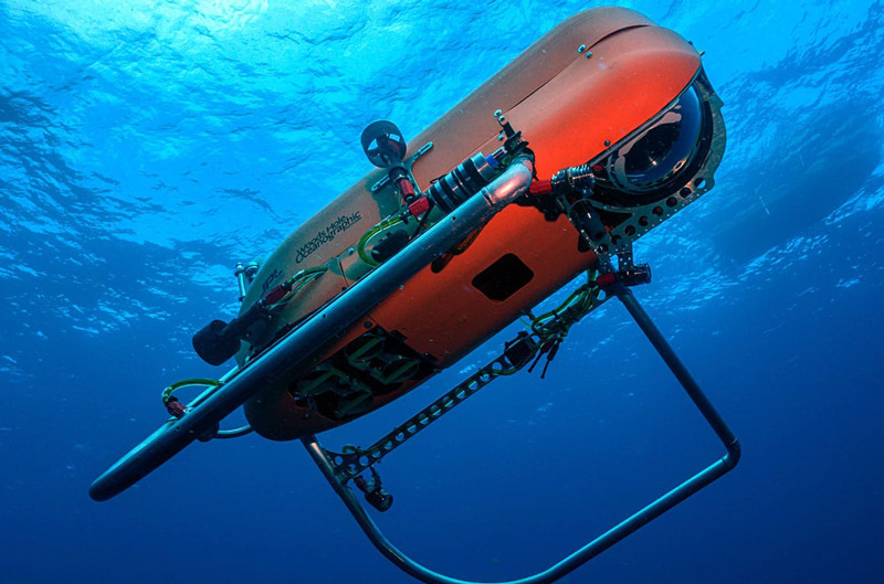
Supported in part by NOAA Ocean Exploration through the OECI, WHOI is testing the next generation of 11,000 meter (6.8 mile) rated Orpheus autonomous underwater vehicles (AUVs), which are designed to explore the deepest parts of the ocean — the “hadal zone,” deeper than 6,000 meters (3.7 miles). Orpheus is the name of both the new class of AUVs, as well as the first vehicle of the class — its twin, Eurydice, will also be tested during the expedition. These AUVs are lightweight, low-cost, deployable from research vessels and ships of opportunity of all sizes, and require minimal specialized technical support. AUVs can also act as force-multipliers during other simultaneous mapping and characterization operations. The Orpheus AUVs are able to work independently or as a networked “swarm” to survey and sample almost anywhere in the global ocean, including the largely unknown hadal zone.
WHOI has been partnering with NASA JPL to implement terrain relative navigation (TRN) software on the Orpheus AUVs to navigate the seafloor. NASA JPL used TRN systems on the Mars Perseverance rover and another on the Ingenuity helicopter to enable them to quickly and autonomously sense their location to avoid hazards. A similar system will also allow the AUVs to avoid hazards and recognize seafloor features that may be of scientific interest.

Orpheus AUVs will enable exploration of the ocean’s greatest depths. Photo by Marine Imaging Technologies, LLC ©Woods Hole Oceanographic Institution. Download image (jpg, 768 kb).
Environmental DNA (eDNA) is the genetic material shed by organisms into the environment (in this case, the water column). By collecting samples of mucus, feces, or tissue particles, scientists can process eDNA to make new discoveries about marine life. eDNA sampling techniques are nondestructive and noninvasive and improve access to hard-to-reach ecosystems like the deep sea. In addition, they can provide comprehensive and accurate biological data with increased efficiency, resulting in timely public access to information. eDNA analysis can be used to establish a baseline of community structure and biodiversity in the marine ecosystem and to detect invasive species, harmful algal blooms, pathogens and parasites, migratory species, cryptic species, and endangered species, and more. The onboard team will be piloting eDNA sampling techniques for NOAA Ocean Exploration to potentially be incorporated into future operations.
Mapping operations will build upon previous efforts by NOAA Ocean Exploration and other partners to map the Blake Plateau and unmapped areas in the U.S. Southeast. Mapping operations will result in high-resolution maps of the seafloor and provide acoustic backscatter data information about the seabed and water column.

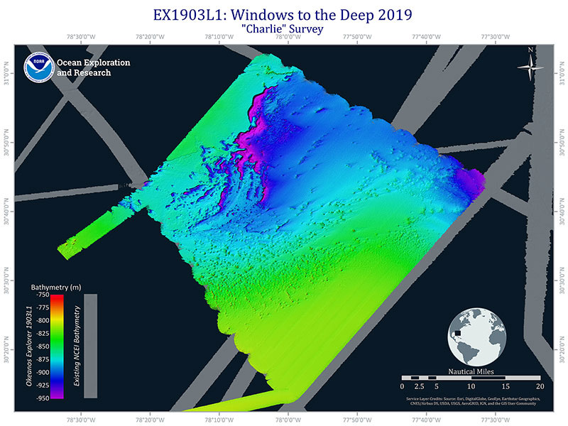
A survey area on the Central Blake Plateau, mapped during the first leg of the Windows to the Deep 2019 expedition. This area is home to distinct mound features, possibly giant mounds of stony corals. Some of these may be targets for AUV deployments. Image courtesy of NOAA Ocean Exploration, Windows to the Deep 2019 expedition Download image (jpg, 540 kb).
The deep waters off of Florida, Georgia, South Carolina, and North Carolina are home to the largest yet discovered contiguous coral mound province found in U.S. waters. However, the deep waters off the Southeastern U.S. remain the most poorly mapped and characterized of the East Coast, and contain a wide diversity of poorly explored deepwater habitats and geological features that are of interest to resource managers and scientists, including biogenic mounds, deep-sea coral and sponge habitats, and fish habitats.
This expedition builds on previous expeditions, including Windows to the Deep 2003, Windows to the Deep 2018, Windows to the Deep 2019, DEEP SEARCH (DEEP Sea Exploration to Advance Research on Coral/Canyon/Cold seep Habitats), and the 2019 Southeastern U.S. Deep-sea Exploration. These expeditions contributed greatly to what we now know about the deep-sea environment along the edge of the Southeastern U.S. continental margin. Every square kilometer of seafloor mapped, and every AUV deployment and CTD cast add to our collective knowledge of deep-sea environments and help to improve our understanding of this region.

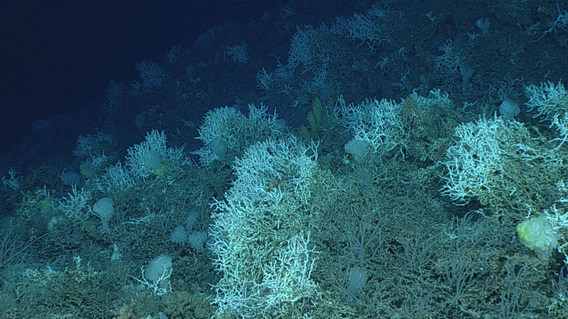
Deep-sea coral reefs like this one seen on Dive 06 of the 2019 Southeastern U.S. Deep-sea Exploration are created by stony corals, Lophelia pertusa, in this case, that form large geological structures over thousands of years. Image courtesy of NOAA Ocean Exploration, 2019 Southeastern U.S. Deep-sea Exploration. Download image (jpg, 560 kb).
Anyone with an internet connection can follow along with the expedition. During the expedition, NOAA Ocean Exploration will share expedition news on social media and on the NOAA Ocean Exploration website. Highlight images, videos, and other information from the expedition will also be posted daily to the office’s Facebook , Instagram , and Twitter accounts.
All standard NOAA Ocean Exploration data collected on this expedition will be available in NOAA’s public data archives within 60-90 days of the conclusion of the cruise and accessible via the NOAA Ocean Exploration Data Atlas.
The team onboard NOAA Ship Okeanos Explorer will include personnel from Woods Hole Oceanographic Institution , NASA Jet Propulsion Laboratory, the Inner Space Center /University of Rhode Island, NOAA Northwest Fisheries Science Center, and the University Corporation for Atmospheric Research. Engineers from the Global Foundation for Ocean Exploration will facilitate data management and ship-to-shore communications. The expedition will be led onboard by NOAA Ocean Exploration.