by Dr. Jeffrey Obelcz, Geology Science Lead, Naval Research Laboratory
Dr. Martha Nizinski, Biology Science Lead, NOAA Fisheries National Systematics Laboratory

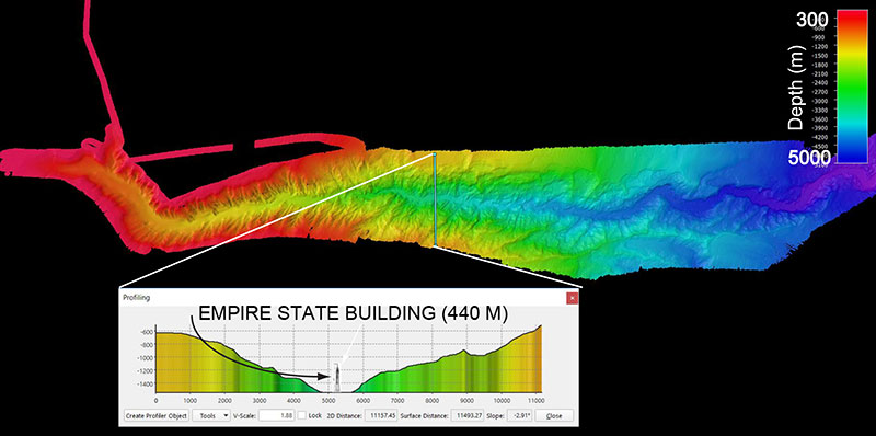
Figure 1: Plan (overhead) view of Hudson Canyon, a shelf-indenting submarine canyon on the U.S. Atlantic Margin offshore New York. The transect demonstrates the width and relief of the canyon, wth the Empire State Building for scale. Image courtesy of the NOAA Office of Ocean Exploration and Research. Download image (jpg, 870 KB).
What’s in a name? For this expedition on NOAA Ship Okeanos Explorer, the name “Deep Connections” refers both to the connections between the United States and Canada strengthened through the this transboundary expedition and to submarine canyons, the “deep connections” between the shallow continental shelf and the deep sea. Submarine canyons are just what they sound like – channels incised into the seafloor, with shapes varying from straight, narrow cuts to meandering valleys. Submarine canyons can be less than a mile offshore on narrow continental margins, such as Monterey Canyon in California, or over a hundred miles from land on wide passive continental margins like the U.S. Atlantic. Particularly large examples, such as Hudson Canyon (Figure 1), can be over 60 kilometers (37 miles) long and 750 meters (2,460 feet) deep.
The fact that submarine canyons are mostly found along continental margins is no coincidence. Steep slopes of the shelf edge are prone to fail, and the ensuing submarine landslides leave gullies and scarps behind. Scarps can expand both laterally and upslope over time, and what started as a small depression can eventually become a submarine canyon.

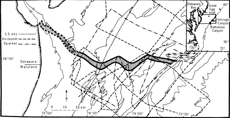
The mapped trace of the ancient Delaware River cutting across the shelf and connecting with Wilmington and Baltimore Canyons. This river channel was active during the Last Glacial Maximum, approximately 20,000 years before present. Rivers contributed to the formation and expansion of particularly large shelf-indenting submarine canyons. Figure from Twichell et al., 1977. Download image (jpg, 206 KB).
During ice ages when sea levels were over 100 meters (328 feet) lower than today, canyons “captured” river systems flowing across the continental shelf, which widened and deepened them even further. These massive “shelf-indenting” submarine canyons are found offshore of rivers such as the Congo, the Hudson, and the Mississippi.
The location, size, and spacing of submarine canyons along a continental margin are heavily influenced by the local geology; softer rocks like carbonates will typically be more canyon-incised than harder substrate.
Submarine canyons are fascinating to scientists because, like the blind men and the elephant, different scientists see submarine canyons as different things. Physical oceanographers marvel at intense tidal currents funneled by canyon confines. Marine geologists see geological history spanning hundreds of millions of years recorded in canyon wall outcrops. Marine biologists focus on the deep-sea corals that settle on hard, steep canyon walls. While different kinds of scientists will tell you submarine canyons are important for different reasons, all agree that they are one of the most important features in the ocean.

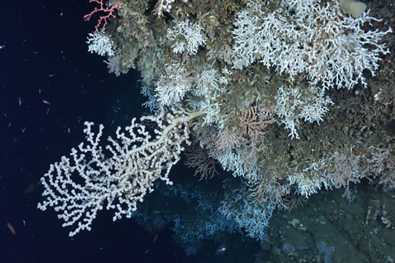
A variety of deep-sea corals found on a ledge in an unnamed canyon between Heezen and Nygren Canyons, including the stony coral Lophelia pertusa, a large white gorgonian Paragorgia (bubblegum coral) and a small red Paragorgia (upper left), and the gorgonian Primnoa (orange, center). Image courtesy of Northern Neighbors: Transboundary Exploration of Deepwater Communities. Download image (jpg, 288 KB).
The processes that interest physical and geological researchers influence the biological assemblages we see in submarine canyons. The flow environment, food supply, and underlying geology all interact to allow for discrete communities of organisms to thrive in the heterogeneous environments found within canyons. Benthic (bottom) communities in canyons tend to be more diverse and productive than other deep-sea habitats. Thus, submarine canyons are often characterized as biological hotspots and targets for conservation.
The other focus of our “Deep Connections” expedition is seamounts. Just as submarine canyons resemble winding river valleys on land, seamounts resemble submerged mountains. Seamounts are thought to be formed by mantle “hotspots,” whereby particularly hot plumes of the Earth’s mantle percolate through the Earth’s crust, forming underwater volcanoes that grow by erupting. If the mantle hotspot is active enough, a chain of seamounts can rise above the ocean’s surface; the most famous seamount chain is the Hawaiian Islands.

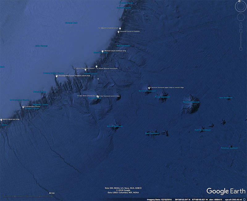
Plan (overhead) view of submarine canyons and seamounts in the northeast Atlantic. The location of submarine canyons and seamounts in such close proximity provides an excellent opportunity to study them side-by-side. Figure generated from Google Earth. Image courtesy of the NOAA Office of Ocean Exploration and Research. Download image (jpg, 1.2 MB).
Seamounts are versatile research topics just as submarine canyons are. Seamount spacing and orientation can help geologists reconstruct the movement of continental plates, as mantle hotspots are relatively stationary while the plates glide over them. Seamounts are also highly productive ecosystems. Like canyons, the combination of physical and geological processes enhances the diversity of organisms found here. High currents, reduced sedimentation, upwelling of nutrient-rich water, and habitat heterogeneity contribute to seamounts being characterized as biodiversity hotspots as well. Their steep walls provide good substrate for deep-sea corals to anchor onto, which form the basis for thriving ecosystems. Seamounts are frequently home to a unique set of species – endemics – that only occur at seamounts and not in other marine habitats.
The U.S.-Canada Atlantic margin is relatively unique in having submarine canyons very close to seamounts, and our expedition will take full advantage of this geological rarity.
Despite their differences, both submarine canyons and seamounts offer a host of intriguing environments and questions for scientists to explore. The steep walls that characterize both features often host deep-sea corals and the ecosystems that flourish around them. Their size, shape, and outcropping strata offer a window into their formational history and geological past. The “Deep connections” between submarine canyons, seamounts, and the organisms that inhabit them make them worthy subjects of research and exploration.
Twichell, D.C., Knebel, H.J., Folger, D.W., 1977. Delaware River: Evidence for its former extension to Wilmington Submarine Canyon. Science 195: 483-485.