By Kasey Cantwell, Expedition Coordinator, NOAA Office of Ocean Exploration and Research
Michael White, Mapping Lead, NOAA Office of Ocean Exploration and Research
Scott C. France, Science Lead, University of Louisiana at Lafayette
Del Bohnenstiehl, Science Lead, North Carolina State University

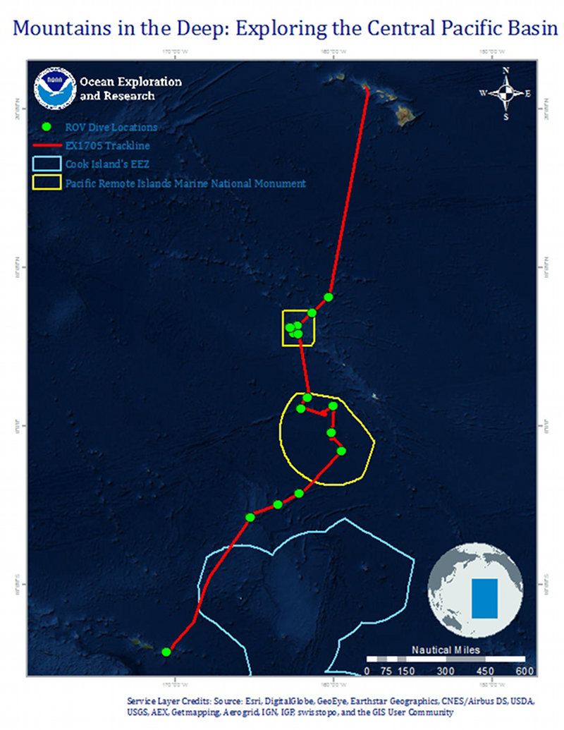
Map of the general expedition operating area. The red line is the rough cruise track from American Samoa to Honolulu during the expedition. The yellow polygons represent the boundaries of the Pacific Remote Islands Marine National Monument, now known as Pacific Islands Heritage Marine National Monument. The light blue polygon designates Marae Moana (Cook Islands). Planned ROV dives are represented by green markers. Image courtesy of the NOAA Office of Ocean Exploration and Research. Download image (jpg, 152 KB).
From April 27 – May 19, 2017, NOAA and partners will conduct an ocean exploration expedition on NOAA Ship Okeanos Explorer to collect critical baseline information about poorly understood deepwater areas in the Pacific. The expedition begins in Pago Pago, American Samoa, and ends in Honolulu, Hawaiʻi, crossing some of the least explored areas in the region. The team will conduct near daily remotely operated vehicle (ROV) dives in American Samoa; the high seas; and the Jarvis Island, Kingman Reef, and Palmyra Atoll Units of the Pacific Remote Islands Marine National Monument (PRIMNM), now known as Pacific Islands Heritage Marine National Monument, before returning to Honolulu.
This expedition is part of the three-year Campaign to Address the Pacific monument Science, Technology, and Ocean NEeds (CAPSTONE), a foundational science initiative to collect deepwater baseline information to support science and management decisions in and around U.S. marine protected areas in the central and western Pacific. CAPSTONE serves as an opportunity for NOAA to highlight the uniqueness and importance of these national symbols of ocean conservation.

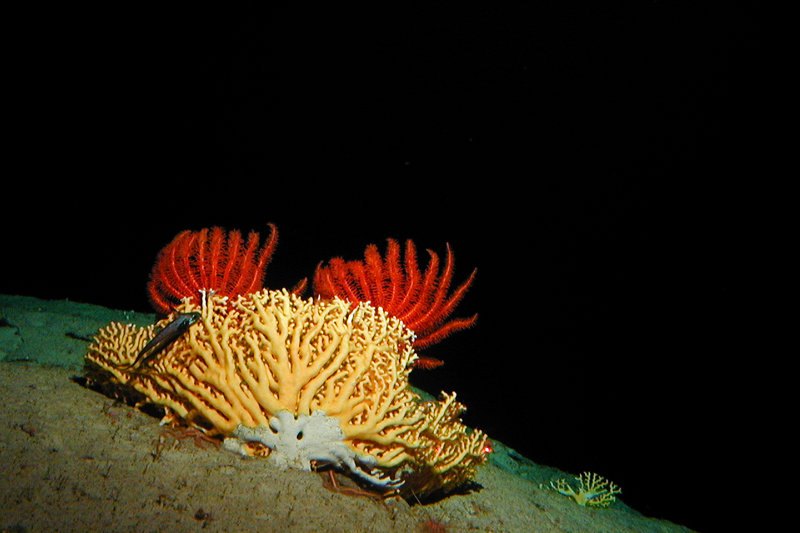
In the deep sea, corals provide habitat for many organisms. This image was collected during the first exploration of the deep waters around Kingman Reef in 2005 by the Hawaii Undersea Research Lab. Image courtesy of NOAA-HURL Archives. Download larger version (jpg, 547 KB).
The Central Pacific Basin encompasses some of the most remote areas on Earth. Large swaths of this region have never been mapped using high-resolution mapping systems and the vast majority of these waters remain unseen by human eyes. The expedition will collect critical data to better understand the origin of seamounts in this area and how the deepwater communities on these seamounts are connected.
There are many basic questions about the region that we don’t currently understand. How were these seamounts formed? How old are they? What biological communities exist there? Through other CAPSTONE expeditions, NOAA has had the opportunity to explore a diversity of deep-sea habitats. Will the ones encountered during Mountains in the Deep be similar? Will there be the same animals? If not, why is that?
With so much unknown in this area, it is nearly impossible for one cruise to answer all of these questions, but we plan to bring back the first puzzle pieces to help solve them. As with many exploration missions, Mountains in the Deep will likely end with more questions than it started with, hopefully spuring the next round of exploration and scientific research.
The Mountains in the Deep expedition will address science themes and priority areas proposed by NOAA and partner scientists and managers. Operations will complement previous and planned work in the area. NOAA priorities for the expedition include a combination of science, education, outreach, and open data objectives that will support management decisions at multiple levels. Goals of the expedition include:

From January 20 to February 11, 2017, NOAA Ship Okeanos Explorer conducted a mapping reconnaissance expedition in PRIMNM. In the Jarvis Unit of PRIMNM, multibeam data revealed an approximate 1,700 meter seamount height difference when compared to previous satellite altimetry. This is a great example of why it is important to map the seafloor using modern, high-resolution sonar systems. Image courtesy of the NOAA Office of Ocean Exploration and Research. Download larger version (jpg, 290 KB).
During the expedition, we will conduct 24-hour operations consisting of daytime dives and overnight mapping operations. The 15 planned ROV dive sites are expected to include deep-sea coral and sponge habitats, bottomfish habitats, and seamounts. We will cover more than 2,400 miles, and we will map every one of those miles.
NOAA works with the scientific and resource management communities to characterize these areas through telepresence-based exploration. Operations use the ship’s deepwater mapping systems, NOAA’s dual-bodied 6,000-meter ROVs Deep Discoverer (D2) and Seirios, and a high-bandwidth satellite connection for real-time ship-to-shore communications.
ROV dives will include high-resolution visual surveys and limited sampling. This expedition will help establish foundational information in the region to catalyze further exploration, research, and management activities.
Live video of dives can be viewed online in real time from April 27 – May 19, 2017, typically from about 8 am to 5 pm SST (3 pm to 12 am EDT).
Telepresence technology allows us to engage the majority of the science team from shore. NOAA uses telepresence technology to transmit data in real time to a shore-based team of scientists who actively participate in expeditions. Scientists participating from around the world contribute their expertise to operations in real time when discoveries are made at sea.
These shore-based scientists interact with the ship through a teleconference line and Internet collaboration tools. Using these communication tools, scientists and students help guide at-sea operations in real time, extending the reach of ocean exploration to more scientists and students than could possibly be accommodated onboard of any single vessel.
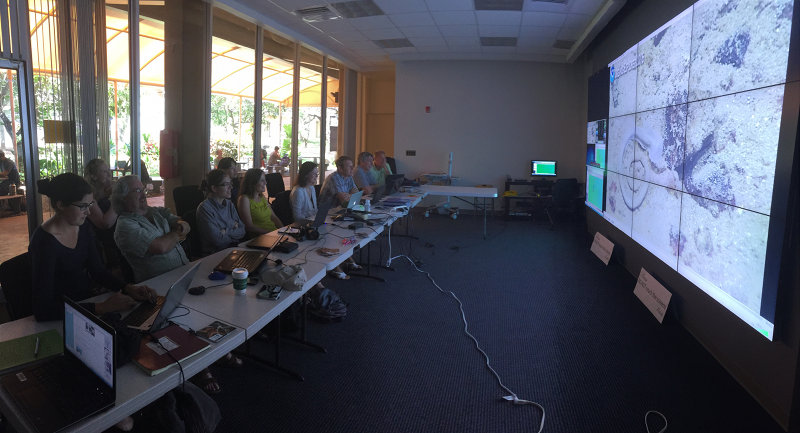
Several scientists will also work together and stand watches at Exploration Command Centers (ECCs). When Okeanos Explorer expeditions first started, ECCs were the only way that scientists could engage with the ship in real time. As technology has advanced, scientists located anywhere with an Internet connection can participate in missions. However, many scientists still prefer to be co-located with their colleagues at an ECC, as is the closest atmosphere to being in the collaborative environment that naturally forms on a ship. Also, working from an ECC removes scientists from their busy lives and allows them to focus on the expedition.

Scientists participating at the University of Hawaii ECC. Collaboration among different fields of study is easily fostered with so many scientists working together in one location. Image courtesy of the NOAA Office of Ocean Exploration and Research. Download larger version (jpg, 8.3 MB).
The same technology that allows scientists around the world to participate in the expedition from land also enables interested members of the public to experience deep-sea exploration, the wonder of discovery, and the fascination of science in real time! The live video feeds are available to anyone online, providing the public with a front row seat to discoveries as they are made.
Web content developed for this expedition includes background essays; mission logs; daily updates; videos and images; and a live video feed. Education materials allow educators and students to engage their classrooms using products tied to the expedition, including standards-based lesson plans, background information, ocean career connections, links to previous Office of Ocean Exploration and Research-sponsored expeditions, and more.