By Heidi Hirsh, Natural Resources Management Specialist, NOAA Fisheries Service, Marine National Monuments Program
Kristen Rex, Natural Resources Manager, Center for Environmental Management of Military Lands (CEMML), Colorado State University

Map showing the location of Wake Island and the Pacific Remote Islands Marine National Monument, now known as Pacific Islands Heritage Marine National Monument. Image courtesy of the NOAA Office of Ocean Exploration and Research, Deepwater Wonders of Wake. Download larger version (jpg, 633 KB).
The NOAA Office of Ocean Exploration and Research conducted mapping operations in and around Wake Island within the Pacific Remote Islands Marine National Monument, now known as Pacific Islands Heritage Marine National Monument during an expedition in March–April 2016. The work in the area is now continuing with two additional cruises: the first with remotely operated vehicle (ROV) dives, mapping, and telepresence July 27–August 19; and the second with only mapping and telepresence August 25–September 11.
Wake Island and the surrounding waters are part of the Pacific Remote Islands Marine National Monument, which lies to the south and west of Hawaiʻi. The Monument is among the largest marine protected areas in the world and represents the most widespread collection of marine life that is under a single country's jurisdiction on the planet.
The monument consists of approximately 1,269,065 square kilometers (370,000 square nautical miles) of ocean surrounding seven islands and atolls in the central Pacific Ocean: Baker, Howland, and Jarvis Islands; Wake, Johnston, and Palmyra Atolls; and Kingman Reef.
Under the authority of the Antiquities Act of 1906, President George W. Bush established the Monument in January 2009 with Presidential Proclamation 8335. And, in September 2014, President Obama expanded the Monument through Proclamation 9173 to protect its abundant marine life, biologically diverse seamount habitats, and various resources of scientific or historic interest.
The Monument islands are cooperatively managed by the Secretary of Commerce (NOAA) and the Secretary of the Interior (U.S. Fish and Wildlife Service), with the exception of Johnston Atoll and Wake Island. Both of these islands are under administrative oversight by the Department of Defense, whereas U.S. Fish and Wildlife Service, National Wildlife Refuge staff currently operate a field camp at Johnston to monitor and eradicate the accidentally introduced Yellow Crazy Ant that kills the migratory and resident seabirds there. Also, National Wildlife Refuges exist at each of the islands within the Monument accept Wake Island. Wake Island is managed by the Pacific Air Forces Regional Support Center, in partnership with the U.S. Fish and Wildlife Service National Wildlife Refuge.
The support center currently operates an active airfield on Wake Island proper that provides support of contingency operations, emergency and planned diverts, and other missions as necessary for Department of Defense operations in the Pacific and beyond. NOAA currently operates a weather observation station and tidal benchmark measuring system at the harbor to support regional forecasting and conducts regular coral reef ecosystem research in the area.
The unique geology, geochemistry, rare biological conditions, and pristine ecosystems provide an ideal location for interdisciplinary research. The mapping efforts undertaen via the Okeanos Explorer may result in the discovery of new seamounts and geologic features that give insight to the ocean floor features, as well as previously undiscovered underwater ships and planes from the Battle of Wake.

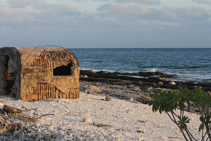
World War II shoreline pillbox at Wake Island. Image courtesy of CSU/CEMML, Kristen Rex.
Wake Atoll has a unique combination of land management jurisdictions and authorities. The entire Atoll has been designated a National Historic Landmark because of the World War II battle that took place there in December 1941. Under the National Historic Preservation Act of 1966, the United States Air Force has increased responsibilities to preserve and protect these historical and significant features.
At Wake Atoll, these features are regularly exposed to tropical wind, weather, and sea air, as well as periodic typhoons, further challenging the preservation and management of these features. Cultural resources at Wake Atoll include archaeological sites, structures, ruins, and landscapes that have local and national historical or cultural significance.
The Pacific Air Forces Regional Support Center manages the following known cultural resources at Wake Atoll:
The location of this World War II airfield at Wake Island also includes important landmark features, including the igloo bunkers that served as U.S. headquarters during the Battle of Wake Island; the Japanese headquarters building; and Japanese aircraft revetments, shelters, bunkers, anti-aircraft artillery control centers, gun mounts, block houses, and pillboxes. In addition, it holds the most intact post-World War II civilian and military structures of Wake Atoll.

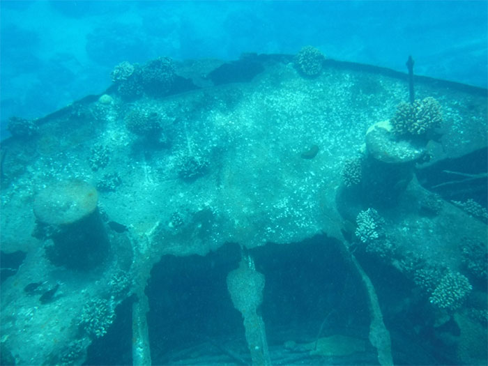
One of the Wake Island shipwrecks just outside the channel to the marina. Image courtesy of USAF / Mark Ingoglia.
The Atoll’s reefs have been the site of six known shipwrecks. Three Japanese craft beached themselves along the southern shore of Wake Island — two during the invasion and one on a supply run. Their wreckage has been partly salvaged for scrap metal, but portions of the vessels remain. Additionally, the remains of two 19th-century sailing craft that foundered on the reefs lie off the eastern shore, and the remains of an unidentified sailing craft have been identified near Heel Point at the northern tip of Wake Island. The wreckage of World War II aircraft and many unexploded bombs have also been reported just beyond the reefs, along with more recent aircraft and missile parts.

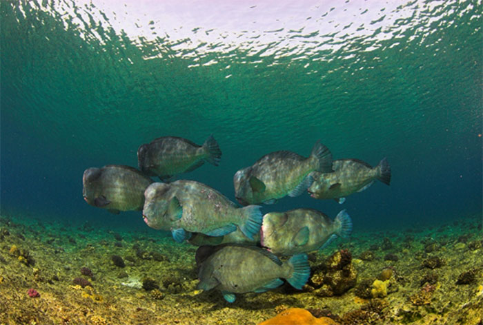
Bumphead parrotfish (Bolbometopon muricatum) at Wake Atoll, the largest known population of this species in the world. Image courtesy of Sergy Bogorodsky.
The scientific research to be conducted on the upcoming Okeanos Explorer expedition to the Wake Island ecosystem is expected to assist sustainable fisheries management and deep-sea education initiatives; improve our understanding of the unique biology, geology, and deepwater habitats of the region; gain a greater understanding of the unique historical past; and offer the opportunity to engage new partnerships, exchange knowledge, and develop innovative tools for sustainable resource management.