By Kelley Elliott - Expedition Coordinator, NOAA Office of Ocean Exploration and Research (Collabralink)
July 31, 2015

The bow of NOAA Ship Okeanos Explorer as she departs Pearl Harbor, Oahu, to commence Leg 2 of the Hohonu Moana: Exploring Deep Waters off Hawaiʻi expedition. Image courtesy of the NOAA Office of Ocean Exploration and Research, 2015 Hohonu Moana. Download larger version (jpg, 5.8 MB).
After many months of planning and coordination, NOAA Ship Okeanos Explorer departed Pearl Harbor, Oahu, this morning at approximately 0930 and got underway to commence Leg 2 of the Hohonu Moana: Exploring Deep Waters off Hawaiʻi Expedition.

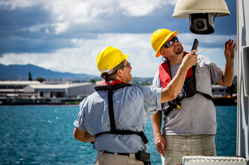
Video engineers Roland Brian and Joe Biscotti work on one of the robotic HD camera’s on the ship’s aft deck while the ship is in port in Pearl Harbor, Oahu. Image courtesy of the NOAA Office of Ocean Exploration and Research, 2015 Hohonu Moana. Download larger version (jpg, 12.1 MB).
After departing the harbor, the ship’s sonar systems were turned on and we will conduct mapping operations during transit to the first remotely operated vehicle (ROV) dive site.
As with many large operations, our team has encountered a few hurdles getting going. Yesterday, while looking at the location of our first planned ROV dive site, we learned that the U.S. Navy is conducting missile testing in the vicinity. As a result, we not only can’t dive there, but will need to go so far out of the way to get out of their testing zone and to the second planned ROV dive site, that we had to cancel one of the planned dives for the cruise. We will instead conduct our first ROV dive on August 2 at the site we originally planned for our second ROV dive – East Necker, or Keoea, Seamount.
The second hurdle discovered this morning is that due to a problem with the satellite connection, we are functioning on reduced bandwidth, and as a result will only stream two video feeds to shore during this cruise.
Thankfully, none of these items are show stoppers and the team is busily preparing for operations. On board the ship, personnel spent much of the day preparing for cruise operations by setting up and testing equipment, getting familiar with shipboard systems and networks, and training new personnel. The science team spent the day preparing for sample collection and processing, preparing ROV dive plans, and getting familiar with control room operations and communications procedures.

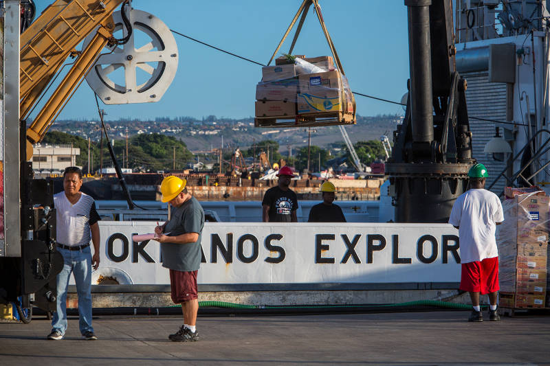
Food stores being loaded onboard in preparation for Leg 2 of the Expedition. Food stores to feed 46 people on the 23 day cruise leg included: 150 lbs of beef, 200 lbs of chicken, 150 lbs of seafood, 120 dozen eggs, 50 gallons of milk, 100 lbs of fruit, 300 lbs of vegetables, 60 lbs of coffee, 15 gallons of icea cream, and 300 ice cream bars. Image courtesy of the NOAA Office of Ocean Exploration and Research, 2015 Hohonu Moana. Download larger version (jpg, 12.4 MB).
The ROV engineering team has been busy going through system checks, preparing the ROV for operations, and practicing with the manipulator arms in preparation for sampling activities. Deck officers conduct passage plan meetings reviewing waypoints, weather, and stability. The medical officer makes seasickness pills available. Ship engineers take tank soundings and run various generator tests. The deck department secures the decks for sea and prepares lines for departure. And everyone loads stores for the galley!
But cruise planning preparations for a telepresence-enabled expedition don’t stop on the ship – most of our science team and many support personnel will be participating from shore. This expedition marks the first time we are conducting telepresence-enabled ROV operations in U.S. Pacific waters. Over the past few months, our team has been getting the word about the expedition out to the broad science community to solicit input and participation from relevant experts and develop the science team.
We have also been working with our partners in the region to set up two new Exploration Command Centers in Hawaii – one at the University of Hawaii at Manoa and another at NOAA’s Inouye Regional Center on Ford Island, Oahu. As personnel on board the ship were busily preparing for operations at sea, the team back on shore was busy getting familiar with the new exploration command centers, the science plan, and the Internet-based tools that would allow them to participate in the expedition from shore.
After months of planning and preparation – the ship is underway and the teams at sea and ashore are ready for operation. Tune into the live feeds and join us as we map and explore the Northwest Hawaiian Islands!