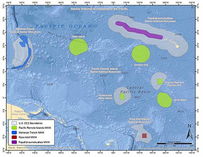

Field activities in 2015 will include work in and around the Papahānaumokuākea Marine National Monument, Hawaiian Islands Humpback Whale National Marine Sanctuary, and Johnston Atoll – part of the recently expanded Pacific Remote Islands Marine National Monument, now known as Pacific Islands Heritage Marine National Monument. Download image (jpg, 96 KB).
Beginning in July 2015, a team of NOAA and external partners, led by the NOAA Office of Ocean Exploration and Research, will initiate the Campaign to Address Pacific monument Science, Technology, and Ocean NEeds (CAPSTONE). Currently planned as a three-year effort, CAPSTONE will focus on systematically collecting baseline information to support science and management needs within and around the U.S. Marine National Monuments and other protected places in the Pacific.
Explorations in 2015 will include work in and around the Papahānaumokuākea Marine National Monument and Johnston Atoll – part of the recently expanded Pacific Remote Islands Marine National Monument.
Many of the areas planned for exploration are already protected as marine monuments and national marine sanctuaries; however, protection is only the beginning of management efforts. These areas are protected because they are unique, biologically rich and diverse, and represent national symbols of ocean conservation.
Goals for this expedition include:
During these expeditions, scientific focus will include:
Searching for large-scale, high-density deep coral and sponge communities. Interest in these communities stems from the fact that deep corals and sponges provide habitat for a variety of marine life, creating regions that are likely rich in overall biodiversity. Additionally, deep-sea organisms are often long-lived and slow-growing, and thus, negative impacts to these communities can be far reaching and create circumstances from which recovery is difficult. It is also quite likely that explorers will encounter marine life that has been rarely or never seen before, with adaptions, behaviors, and appearances completely new to science.
Collecting baseline data critical to managing and protecting vulnerable deep-sea marine habitats.
The relatively pristine and undisturbed deepwater sites explored during CAPSTONE will provide an unprecedented “natural laboratory” to collect essential data that will be used to guide management and protection efforts, particularly in the face of environmental change and emerging economic interests.
During Leg I of the expedition, the ship will conduct multibeam sonar mapping operations in targeted areas in order to collect data useful in selecting specific locations for sending down the remotely operated vehicle for more specific, detailed explorations. The main area of interest is the Johnston Atoll region.
Legs II-IV will employ the complete exploration strategy of the Okeanos Explorer: bathymetric mapping using multibeam sonar; water column exploration using a Conductivity, Temperature and Depth Profiler (CTD); and remotely operated vehicle imaging and video. Scientists from around the world will be participating in the explorations in real time through telepresence technology as they investigate biological habitats and geologic history of the Northwestern Hawaiian Islands, the main Hawaiian Islands, Geologists Seamounts, and Johnston Atoll. Expedition participants are particularly excited as this mission will mark the first exploration of habitats deeper than 2,000 meters in Papahānaumokuākea Marine National Monument and the first look at any deep-sea habitats deeper than 366 meters in Johnston Atoll.
During Legs II-IV of the expedition, limited samples will be carefully collected using the Deep Discoverer remotely operated vehicle manipulator arms. Essential scientific sample collections will focus on:
Even as the importance of deep areas of the ocean in our everyday lives continues to increase, our knowledge of these areas remains limited. The NOAA Office of Ocean Exploration and Research is providing scientists and resource managers with access to basic information about deep-sea habitats and life forms so that they can prioritize future management and research efforts. This multi-year project will highlight the uniqueness and importance of these marine protected areas, both locally and to the world.