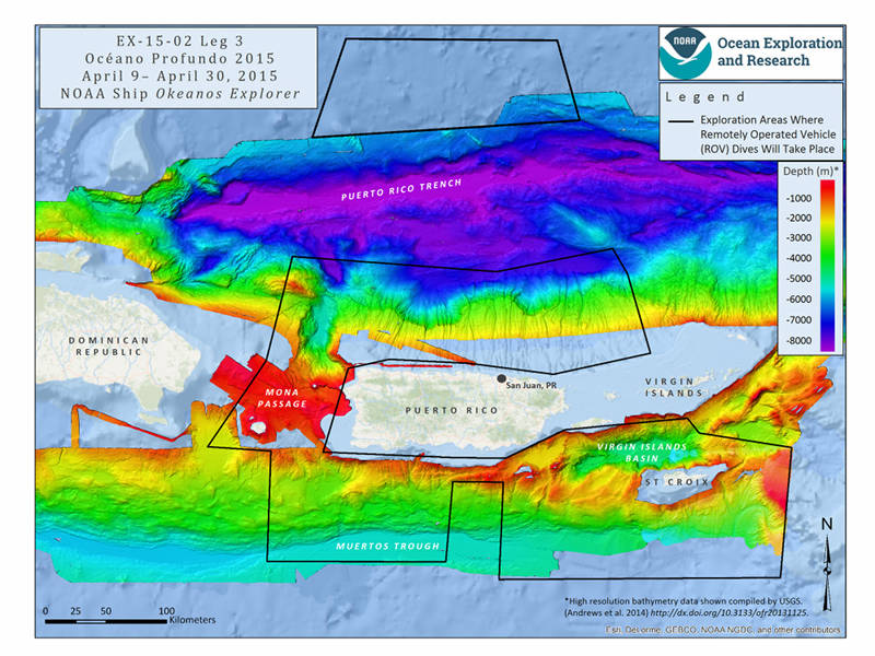

Mission map showing the operating areas, with priority areas outlined in black, for Leg 3 of Océano Profundo 2015. Map created with ESRI ArcMap software and data displayed is provided by ESRI, Delorme, GEBCO, USGS, NOAA NGDC, and other contributors. Image courtesy of NOAA Office of Ocean Exploration and Research. Download larger version (jpg, 2.3 MB).
From April 9 to April 30, 2015, NOAA Ship Okeanos Explorer will explore largely uncharted deep-sea ecosystems and seafloor in the vicinity of Puerto Rico and the U.S. Virgin Islands. During Leg 3 of Océano Profundo 2015: Exploring Puerto Rico’s Seamounts, Trenches, and Troughs, our at-sea and shore-based science teams will work together to investigate unknown and poorly known areas, including the Puerto Rico Trench, Muertos Trough, Mona Passage, and the Virgin Islands Trough.
Priority operating areas for this three-leg, 52-day expedition were identified by resource managers and federal and state partners and through broad participation of the marine science community. Legs 1 and 2 focused on mapping the seafloor where primarily only low-resolution satellite or topographic data existed previously. Leg 3 of the expedition will feature some of the deepest remotely operated vehicle (ROV) dives ever conducted in the region and will collect critical deep-water environmental data that will improve ecosystem understanding and inform federal and local resource managers.
As a special feature for this expedition, we will be posting content periodically in Spanish on the Ocean Explorer website, in addition to our usual daily updates, highlight images and videos, and mission logs.

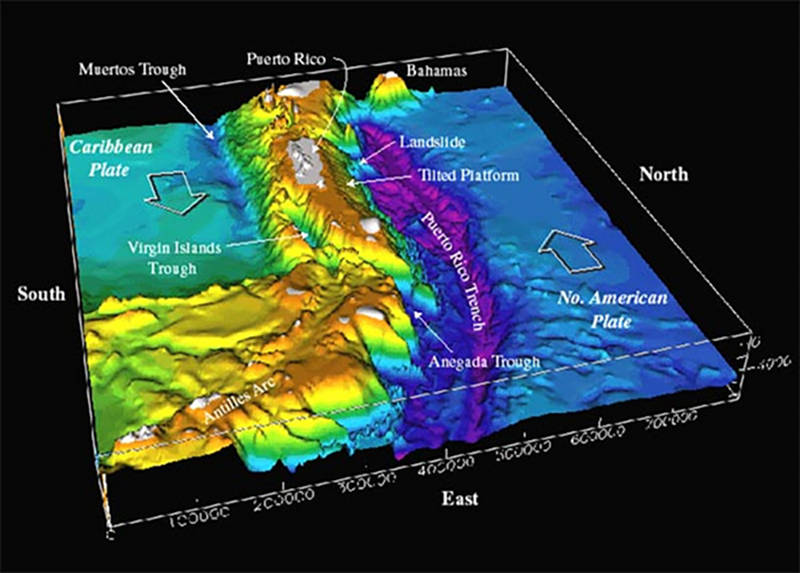
Bathymetry of the northeast corner of the Caribbean Plate, including the Puerto Rico Trench, collected during the 2003 Puerto Rico Trench Expedition. Image courtesy of U.S. Geological Survey. Download larger version (jpg, 75 KB).
A diversity of seafloor features lie just offshore Puerto Rico and the U.S. Virgin Islands that include trenches, seamounts, numerous submarine canyons, valleys, and troughs. These features likely contain valuable and vulnerable ocean resources, but very little is known about them, making this an important area to survey. It is highly likely that new and rare observations of numerous seafloor communities (including deep-sea corals) will be recorded in the region.
The complicated bathymetry of the seafloor of this region is a consequence of plate tectonics—the theory that describes the large-scale motion of the various plates that make up the outer shell of the Earth. Specifically in this area, two plates are interacting with each other. Here, the North American Plate is sliding very obliquely underneath the Caribbean Plate, and it is this motion that explains the origin of the Puerto Rico Trench, the deepest trench in the Atlantic Ocean, and the eighth deepest trench in the world. At its deepest, the Puerto Rico Trench is approximately 8,800 meters deep and it extends over 800 kilometers in length.

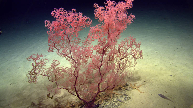
During the Seamounts of the Anegada Passage Expedition just offshore the nearby British Virgin Islands, the science team encountered this large colony of black coral. Hopefully, ROV Deep Discoverer will have similar luck! Image courtesy of Ocean Exploration Trust. Download larger version (jpg, 465 KB).
Also, because this region lies at the boundary between two tectonic plates, it is very geologically active with significant geohazards, such as earthquakes and tsunamis. In 2003, the NOAA Office of Ocean Exploration and Research partnered with the U.S. Geological Survey to collect sonar datain the area and produced the first-ever high-resolution seafloor map in this region. We will leverage this data to plan and execute ROV operations and collect additional mapping data to fill data gaps.
Despite the role that oceans play in supporting our well-being, 95 percent of the ocean remains unexplored. Increasing baseline knowledge of ocean habitats is critical to the conservation and preservation of these remarkable ecosystems. Exploratory missions, such as those conducted by Okeanos Explorer, are necessary to expand our knowledge of the unknown and to provide baseline data for resource managers.

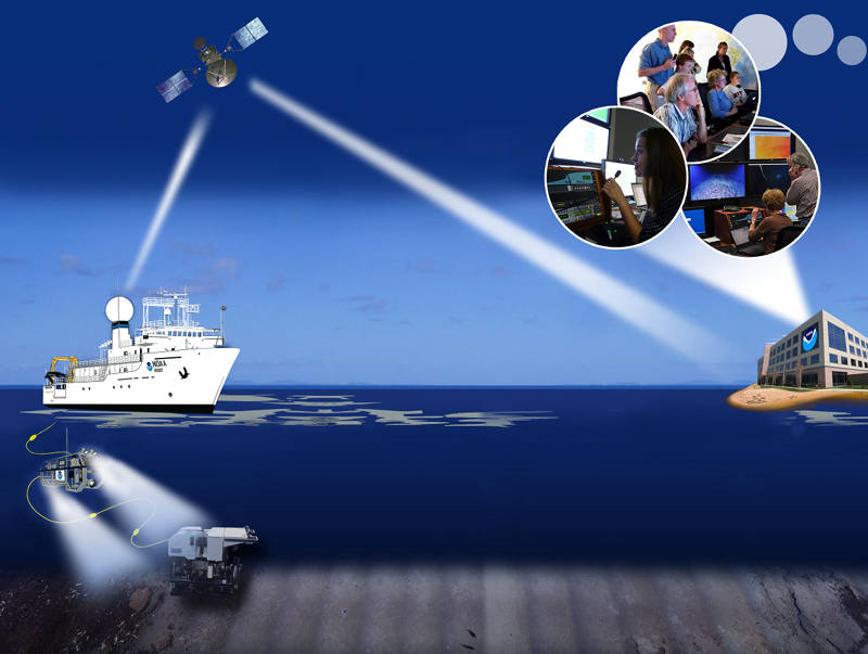
NOAA Ship Okeanos Explorer uses telepresence technology to transmit data in real-time to a shore-based hub where the video is then transmitted to a number of Exploration Command Centers located around the country as well as to any internet enabled device. Access to the video and a suite of Internet-based collaboration tools allow scientists on shore to join the operation in real-time and allows the general public to follow along with the expedition. Image courtesy of NOAA Office of Ocean Exploration and Research. Download larger version (jpg, 1.1 MB).
As with all Okeanos expeditions, Océano Profundo 2015: Exploring Puerto Rico’s Seamounts, Trenches, and Troughs will feature high-definition video streamed live to shore from NOAA’s Deep Discoverer (D2) remotely operated vehicle and Seirios camera platform. D2 and Seirios will provide scientists and audiences onshore with the very first video footage from many of the deep-water areas we’ll explore. We never know exactly what we will find, so tune into the live feeds to see what we discover next!
This expedition provides extensive opportunities for the public to connect to the mission. The web pages for this expedition include background content; mission logs; daily updates; videos and images; near real-time ship tracking features; and a live video feed.
Educators and students can engage their classrooms through the Expedition Educational Module, which provides access to products tied to the expedition, including standards-based lesson plans, background information, ocean career connections, links to previous Office of Ocean Exploration and Research-sponsored expeditions, and more.
¡Ven con nosotros a explorar los ambientes desconocidos del Océano Profundo!