By James Austin, Co-Science Team Lead (Geological Sciences) - University of Texas at Austin

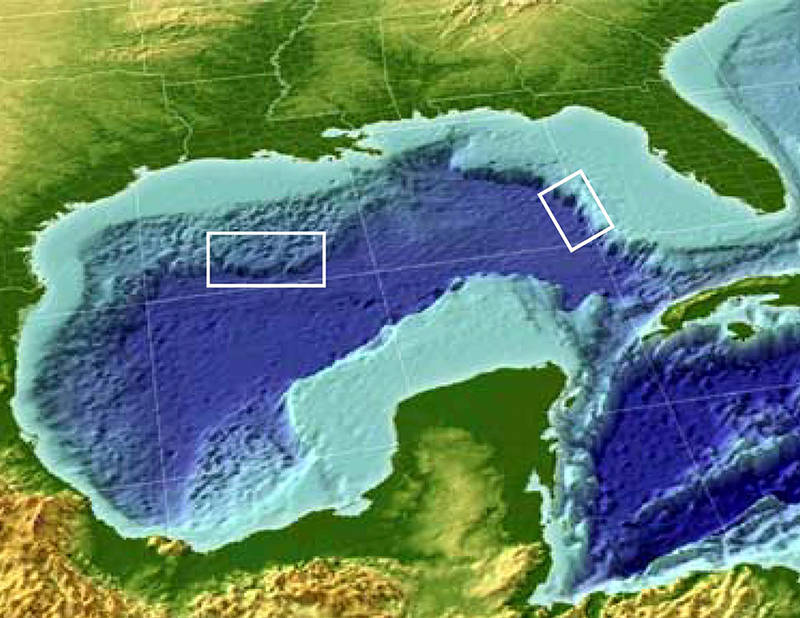
The two operating areas for Okeanos Explorer in April 2014. The western focus encompasses a huge area of subsurface salt movement and resultant deformation of the overlying sediments, creating complex seafloor topography. In this area, NOAA will use its remotely operated vehicles (ROV) and seafloor mapping systems to examine potential seeps, explore shipwrecks, and look at diverse biological habitats in different water depths, including several submarine canyons (Alaminos, Keathley and Bryant) and the adjacent Sigsbee Escarpment. To the east, a shorter series of ROV dives will examine deep-water coral habitats in an area known as the central Florida Escarpment. Figure modified from ESRI, 2000. Download larger version (jpg, 627 KB).
In April 2014, the ocean exploration vessel NOAA Ship Okeanos Explorer will conduct an approximately three-week expedition to two areas in the Gulf of Mexico: the north-central part of the basin, along and north of a steep slope/geologic feature known as the Sigsbee Escarpment, and the central part of the West Florida Escarpment.
The Gulf of Mexico, the ninth largest body of water in the world, is located at the southern end of North America, and is bordered by the United States to the north (Florida, Alabama, Mississippi, Louisiana, Texas), five Mexican states to the west (Tamaulipas, Veracruz, Tabasco, Campeche, Yucatan), and the island of Cuba to the southeast. The Gulf covers approximately 600,000 square miles.
The Gulf of Mexico basin appears to have formed ~200 million years ago as the result of rifting within North America as the supercontinent known as Pangea began to break up. Rifting and the accompanying formation of "stretched" or "transitional" continental crust took several tens of millions of years.
Intermittent advance of the sea into the rifting/extending continental area ~160 million years ago resulted in the formation of extensive salt/evaporite deposits known today in the north- and south-central Gulf of Mexico. Continental drift accompanied the formation of oceanic crust from ~160 to 135 million years ago in the central Gulf basin, as what is now the Yucatan peninsula moved southward towards its modern position.

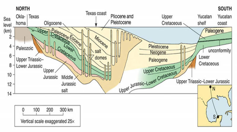
An idealized north to south cross section of the Gulf of Mexico. Note the presence of salt diapirs and ”piercement” structures in both the northern and southern parts of the Gulf basin, which complexly deform overlying thick sediments. NOAA will examine a number of locations in the northwestern Gulf associated with potential hydrocarbon seeps, diverse biological habitats, and several shipwrecks. Image courtesy of H. Levin, 2013. Download larger version (jpg, 794 KB).
Since the end of seafloor spreading and generation of oceanic crust in the Gulf of Mexico ~135 million years ago, the basin has been a stable geologic province characterized by the persistent subsidence of its central part, probably due at first to thermal cooling and later to sediment loading as the basin filled with thick prograding clastic sediment wedges along its northwestern and northern margins, particularly during the last 60 million years.
Sediment thicknesses in the central Gulf of Mexico exceed 12-14 kilometers. As the Jurassic-age salt deposits have been covered and pressured by younger overlying sediments, these less dense evaporites have deformed and begun to rise, creating complex pillars or domes known as “diapirs.”
These salt diapirs are impervious to fluid flow, but allow hydrocarbons from depth to migrate upward toward the modern seafloor along their edges. As a result, the modern floor of the Gulf of Mexico is likely the site of thousands of naturally occurring oil and gas “cold” seeps. Some of these seeps have been investigated by recent Okeanos Explorer expeditions, and more potential seeps will be investigated during the 2014 Gulf expedition.
Where the salt actually reaches the seafloor, it begins to dissolve, creating the complex “collapse” features that characterize the seafloor of the north-central Gulf of Mexico. The downslope edge of this rising and collapsing salt complex forms the Sigsbee Escarpment. Major pathways for downslope sediment movement also cross this area; several of these, including the Alaminos, Keathley and Bryant canyons, will be examined during the April 2014 expedition.

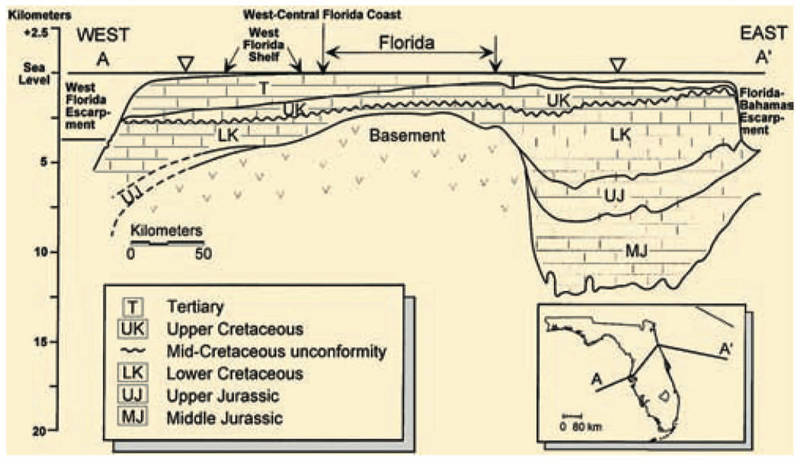
Generalized west-to-east cross section extending across the Florida and Bahamas platforms. The Florida carbonate platform was built on mostly Paleozoic and Mesozoic rocks that once formed part of Africa and South America, prior to the break-up of the supercontinent Pangea. This older basement high forms the backbone of peninsular Florida. In some places, the carbonates are ~14 kilometers thick. This huge platform is defined by two major submarine erosional escarpments—the western one is the West Florida Escarpment (approximately two kilometers relief), on the central part of which the Okeanos Explorer’s ROV will dive in April 2014 (figure courtesy A. Hine, 2009). Image courtesy of A. Hine, 2009. Download larger version (jpg, 1.6 MB).
To the east, the stable Florida platform was not covered by the sea until ~140 million years ago, while the Yucatan platform was not covered until ~100 million years ago. After both platforms became submerged, the formation of large accumulations of approximately flat-lying carbonates has characterized the geologic history of these two stable areas and the Bahamas Platform east of Florida. These carbonate platforms at one time rimmed the entire area, but beginning ~70 million years ago, the western flank of the Gulf basin has undergone compressive deformation, which created the Sierra Madre Oriental of eastern Mexico.
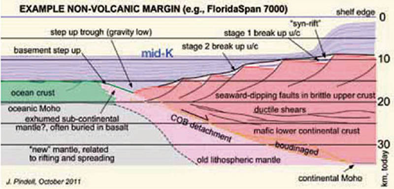
This thick carbonate platform overlies a complexly deformed older set of crustal structures, from rifted continental crust to the transition from those rifts to deeply buried oceanic crust to the west. These structures are now being revealed by deeply penetrating seismic reflection profiles and also velocity characterizations derived from seismic refraction; the latter give us a general idea of the rock types that compose this basement complex.
A shorter series of remotely operated vehicle dives on the West Florida Escarpment will concentrate on both shallow and deep targets to characterize deep-water coral habitats.

A schematic cross section of interpreted rift-related features forming the crustal foundation of western Florida’s southern province, a so-called non-volcanic margin. This cross section has been derived from recently collected deep-penetration seismic reflection profiles collected by industry. The position of the West Florida Escarpment is shown schematically at the upper right. Figure from J. Pindell, 2011. Download image (jpg, 54 KB).