
by Jason Chaytor, Research Geologist, U.S. Geological Survey
August 13, 2013
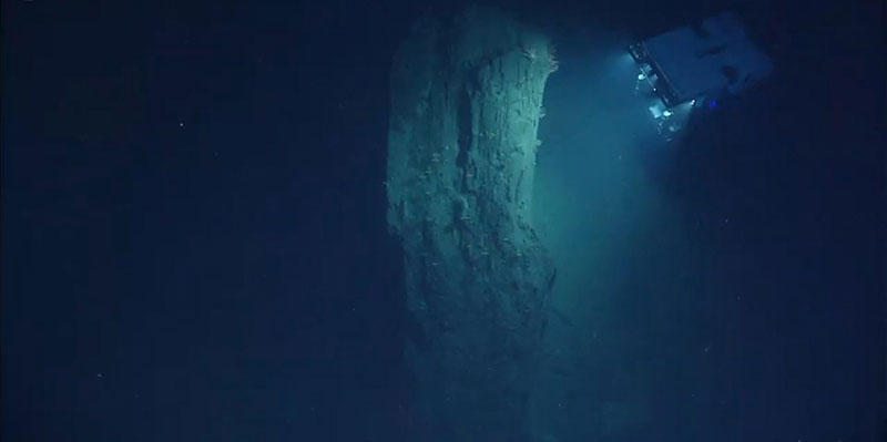
ROV D2 inspecting a large block of mudstone displaced from the wall of Heezen Canyon. Image courtesy of the NOAA Office of Ocean Exploration and Research, Northeast U.S. Canyons Expedition 2013. Download larger version (jpg, 203 KB).
During the long summer days of July and August, NOAA Ship Okeanos Explorer, remotely operated vehicle (ROV) Deep Discoverer (D2), and the cadre of scientists and technicians both aboard ship and ashore have had the rare opportunity to visit more than 10 submarine canyons along the U.S. Atlantic continental slope during the Northeast U.S. Canyons cruise. While some of these canyons, notably Atlantis, Hydrographer, Oceanographer, and Lydonia, have been visited many times in the past, the rest (Block, Alvin, Heezen, Nygren, Welker, and several unnamed minor canyons) remained virtually (no pun intended) visually unexplored.
While the diversity and density of the biology that inhabit these canyons have left the scientists and many citizen scientists in awe, the rare opportunity to observe the varied and dynamic geology of these canyon systems has provided the opportunity to re-evaluate the way in which submarine canyons evolve over a range of time scales, from decades to millions of years (as far back as the Cretaceous).
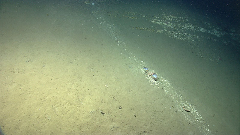
"Recent" sediment transport down the wall of Lydonia Canyon. The bivalve in the center of the image were carried downslope as part of the sediment flow. Image courtesy of the NOAA Office of Ocean Exploration and Research, Northeast U.S. Canyons Expedition 2013. Download larger version (jpg, 1.3 MB).
Canyons such as those investigated during the cruise not only act as a pathway for sediments to move from the terrestrial and shallow marine environment to the deep-sea, but because they cut deeply through continental margins, they reveal tens of millions of years of Earth history. Such long-term geologic records can usually only be read by geophysical imaging and deep drill holes.
Certainly one of the most important outcomes (at least in the opinion of this geologist) of visiting such a large number of submarine canyons across a wide section of the northern U.S. Atlantic continental margin has been the insights gained into the way in which these systems evolve and the mechanisms by which change is accomplished and accommodated. While new observations of the mechanisms of change within submarine canyons contributes to the fundamental understanding of continental margins, it also provides valuable insights into the stability of the rocks and sediments offshore of one of the most urbanized coasts on Earth. The investigation of marine geohazards such as submarine landslides is one of the primary goals of the U.S. Geological Survey as part of the Northeast U.S. Canyons cruise.
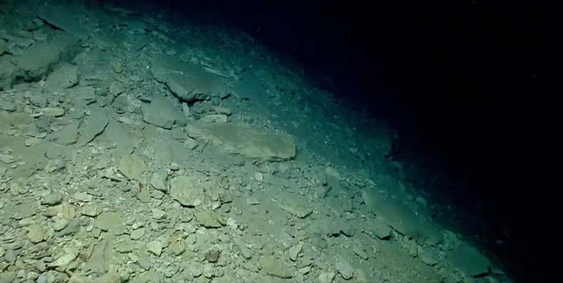
Debris material of various sizes and shapes accumulated in a debris apron at the base of a wall in Block Canyon. Image courtesy of the NOAA Office of Ocean Exploration and Research, Northeast U.S. Canyons Expedition 2013. Download larger version (jpg, 247 KB).
The way the walls of the canyons fail (crumble), size of the failures, evidence of sediment transport along the walls of the submarine canyons, and the time scales over which they have occurred have been truly remarkable. The stratigraphy (the different layers of rock) exposed in each canyon; the steepness of the bathymetry; and the amount of biological, chemical, and physical erosion of the rocks that has occurred are the primary controls on the style and intensity of wall failures found within the canyons.
Evidence of the style of failures of the walls was observed in two ways:
Debris aprons and talus slopes were found in all canyons visited, with rocks ranging from golf-ball to boulder size (some as big as a large car). We found flat and angular rocks (tabular blocks) as wells as some that were more rounded. The shape of the rocks is indicative of both the type of rock (and its strength), how it fractures and breaks off the canyon walls, and how far the rock may have traveled before it arrived at its final resting spot (rounded rocks may have traveled significantly further than the more angular ones).
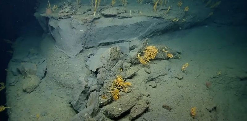
"Recent" rockfall and spalling failure exposing a clean wall section within Oceanographer Canyon. Image courtesy of the NOAA Office of Ocean Exploration and Research, Northeast U.S. Canyons Expedition 2013. Download larger version (jpg, 429 KB).
We found the largest debris blocks in canyons where the walls were made of mudstone and siltstone, such as Hydrographer, Oceanographer, and Heezen canyons and the deep dive in Block Canyon. During dives in the canyons where calcium carbonate-rich rocks (limestones, chalks, and carbonate-cemented rocks) were exposed (Alvin, Atlantis, Block, Nygren and Lydonia canyons), spalling-type failures and brittle fracture of thin, very strong rock layers was most common. Bio-erosion, in the form of burrows and surficial scrape marks and physical abrasion (which forms rills, chutes, and other small channel-like features in the walls) of the carbonate-rich rocks tends to erode the walls at a different rate but over a much larger area. The organisms responsible for the bio-erosion and the triggering mechanisms that cause wall destabilization still remain to be determined.
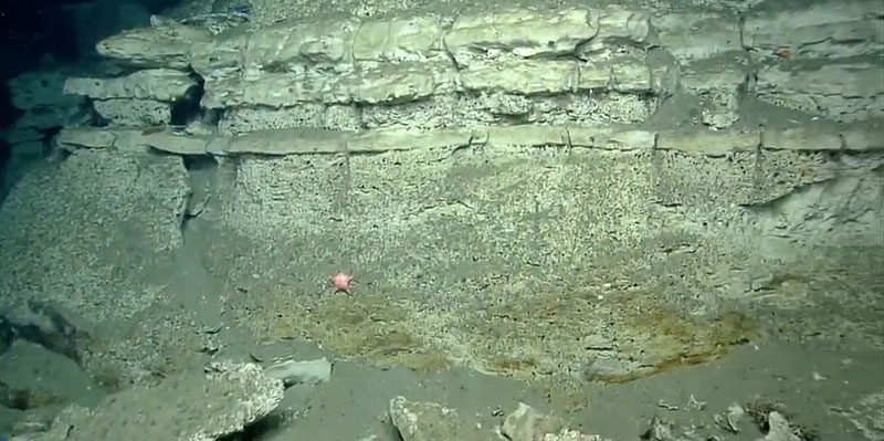
An example of the layered nature and differential erosion of the stratigraphy exposed along the walls in Block Canyon. Thinner layers are most likely porcellanite and the thicker bio-eroded layers are probably chalk. Image courtesy of the NOAA Office of Ocean Exploration and Research, Northeast U.S. Canyons Expedition 2013. Download larger version (jpg, 359 KB).
While observations made during these recent D2 dives highlight that the canyons are very dynamic systems that continue to change to the present day, the rate at which the walls fail and sediment enters and is transported through the canyon system still remains unknown. During numerous dives we have seen both “fresh” or clean failure and talus surfaces and older failure features that have are draped by sediment, encrusted by organisms, and coated in manganese (which takes a REALLY long time to accumulate) in very close proximity to each other. Given the limited amount of ground that D2 can cover during a dive, the source of all of these different age materials can often not be identified. So much work remains to be done, we have only just scratched the surface.
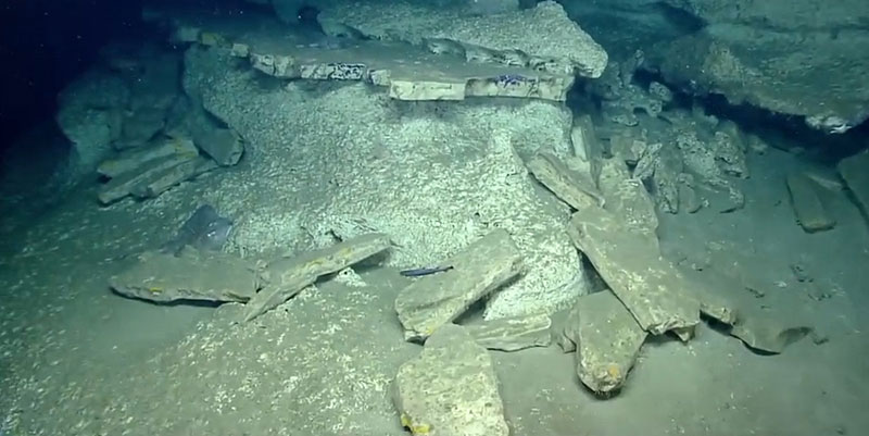
Differential erosion between weaker (possibly chalk) and stronger (porcellanite?) lithologies result in tabular slab failure of the stronger rocks. Weaker rocks have undergone significant bio-erosion. Image courtesy of the NOAA Office of Ocean Exploration and Research, Northeast U.S. Canyons Expedition 2013. Download larger version (jpg, 311 KB).