By Mike Cheadle, Geophysicist - University of Wyoming
and Barbara John, Geologist - University of Wyoming

Fig. 1 - Profiles of Mt Dent on west of the Mid-Cayman Spreading Center (red) and Mt Everest (yellow) shown at the same scale. Mt Dent is clearly a big (undersea) mountain. Image courtesy of NOAA Okeanos Explorer Program, MCR Expedition 2011. Download larger version (jpg, 139 KB).
Mid-ocean ridges are the topographic manifestation of where the Earth’s tectonic plates separate and spread apart and new oceanic crust is created. The Mid-Cayman Rise is an example of one of these ridges and forms part of the boundary between the North American and Caribbean tectonic plates. It is unique because it is one of the world’s deepest mid-ocean ridges extending to more than 6km below the sea surface at its deepest point, and is thought to generate some of the thinnest (approximately 3km) oceanic crust on Earth. The plates on either side of the ridge spread apart at a very low rate of 15-17mm/yr, that’s less than half the rate a human’s finger nail grows! Ridges that spread at this very low rate are called ultra-slow spreading ridges and are a hot topic for ocean exploration, because they are relatively poorly understood.

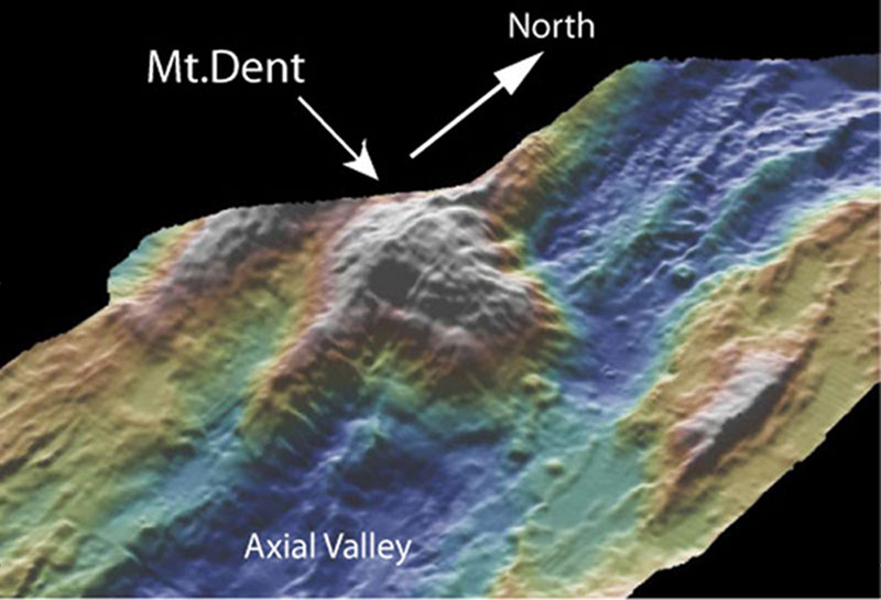
Fig. 2 - 3-D perspective bathymetric map looking northwest, showing Mount Dent emerging from the axial valley of the Mid-Cayman Spreading Center. Image generated using GeoMapApp from the Ridge Multibeam Synthesis. Image courtesy of NOAA Okeanos Explorer Program, MCR Expedition 2011. Download image (jpg, 73 KB).
Extreme topography is a characteristic of slow spreading ridges. The adjacent figure (Figure 1) shows a comparison of Mt. Dent, one of the undersea mountains at the Mid-Cayman Rise and Mt. Everest. This topography is generated by large extensional faults that partly accommodate the plate separation. Two processes occur within the crust at mid-ocean ridges to accommodate plate separation, either magma is injected into the gap that forms as the plates pull apart or major faults form that allow blocks of crust to slide over one another, much like what happens when a row of books on a shelf falls over. At fast spreading ridges, like the East Pacific Rise, the injection of magma to simply fill the gap is the dominant process and so the sea floor topography, called ‘bathymetry’ is relatively smooth. In contrast, at slow and ultraslow spreading ridges, the crust and uppermost mantle is cold and magmatism is suppressed and hence faulting dominates the plate separation process.
For reasons we don’t fully understand, in some cases the faults that accommodate the plate separation keep moving for large distances up to 10’s to 125km, like two enormous books sliding past each other, forming some of the largest offset faults on the Earth. But unlike the books, the Earth’s crust is relatively weak at the very slow rates at which the plates are moving and so the crust bends or rolls-over under the influence of gravity to form enormous domal mountains like Mt. Dent in the middle of the Mid-Cayman Rise. The seafloor making up the surface of Mt. Dent is literally the fault surface and rocks below were pulled out from beneath the ridge axis. The faults are called detachment faults and the largest one we know of is found in in the Philippine Sea, with an offset of 125 kilometers and covering more than 5500 square kilometers, about twice the total land area of Rhode Island. But this might not be the biggest one, because much of the mid-ocean ridge system is yet to be explored in detail.

Fig. 3 - The Ruby Mountain continental core complex in Nevada. The mountains rise 1500m from the plain and were formed by low angle extensional faulting. It is features like this that led to the naming of oceanic core complexes. Image courtesy of NOAA Okeanos Explorer Program, MCR Expedition 2011. Download image (jpg, 187 KB).
Detachments faults probably originate as high angle faults that dip at 60o towards the ridge axis and extend to depths of 5 to 8 km below the sea floor. The ingress of sea water into cracks associated with the detachment faults to depths of several kilometers can lead to the formation of weak, highly altered and metamorphosed rocks. Because of their weakness, these altered rocks may localize deformation and facilitate gradual slip at a shallow angle as the faults rollover. Thus, water plays a key role in allowing detachment faults in the crust to slip at low angles. At depth, slip is probably accommodated by ductile flow (like taffy) and indeed rocks that exhibit ductile deformation are found on the surfaces of these faults.
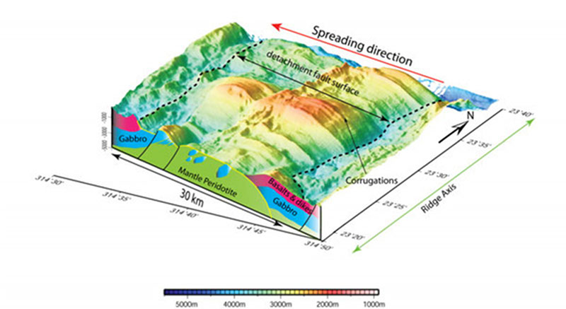
The undersea mountains formed by these large faults have been termed ‘oceanic core complexes’ because of their similarity with continental core complexes, one example of which is found in the Ruby Mountains of Nevada (Fig. 3). Oceanic core complexes were first discovered in the 1990’s along the Mid-Atlantic Ridge, but have subsequently been found at most slow and ultra-slow spreading ridges; in fact it has become recognized that they can form up to 60% of the ridge length in some locations. These oceanic core complexes expose deep rocks from the crust and mantle from beneath the ridge axis revealing how the Earth’s crust grows in these locations, which is why they are currently of great interest and one of the reasons why this expedition is visiting Mt. Dent. Fig. 4 shows a similar core complex from 23oN on the Mid-Atlantic Ridge. The bounding detachment fault forms the smooth corrugated surface of the domal structures with the cross-section at the front of the figure showing that the crust of oceanic core complexes is likely formed of a mixture of mantle peridotite and frozen/intruded magma from the mantle called gabbro. The surfaces of oceanic core complexes are one of the few places in the world where we can visit and sample the Earth’s mantle, even if we have to use the world’s deepest going submarines. Normally the mantle is covered by 7-80km of the Earth’s crust.

Fig. 4 - The Kane oceanic core complex from 23oN on the Mid-Atlantic Ridge. This is one of the most spectacular core complexes we’ve discovered with the smooth detachment fault surface clearly visible. The cross section shows what the crust is likely made of: green represents mantle peridotite; blue represents frozen mantle melts forming gabbro intrusion and magenta represents the basalt lavas and sheeted dikes that normally overly the gabbros. Image courtesy of NOAA Okeanos Explorer Program, MCR Expedition 2011. Download larger version (jpg, 331 KB).
Importantly and one of the reasons for this expedition, intense hydrothermal activity seems to be strongly correlated with oceanic core complexes. Some of the largest known hydrothermal systems, such as the Trans-Atlantic Geotraverse (TAG) hydrothermal field on the Mid-Atlantic Ridge, occur on oceanic core complexes. Fluids circulating along the detachment fault systems forming the core complex extract and mobilize metals such as copper, lead and zinc, from the surrounding rock and concentrate them as ore minerals near the seafloor. These hydrothermal systems are also uniquely rich in hydrogen and methane suggesting that these systems could host abundant and unique deep-sea life. The diversity of the deep-sea and subsurface biosphere in these locations has only just begun to be explored.