Understanding of Methane Seep Formation and Prevalence on U.S. Atlantic Margin Advanced by New Study
A major new study on the distribution and origin of methane seeps on the U.S. Atlantic margin — the seafloor between the coast and the deep ocean — expands the inventory of methane seeps (also called cold seeps) between the South Atlantic Bight and Georges Bank and explores the processes that contribute to their formation.

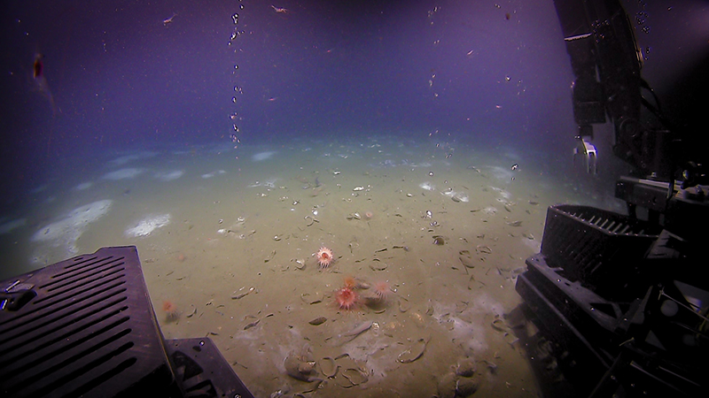
During a remotely operated vehicle dive at the Bodie Island seeps field on the North Carolina margin, two bubble streams were seen emanating from relatively bare seafloor. The background seafloor has white Beggiatoa bacterial mats, and the foreground has dead and live Bathymodiolus mussels and pink anemones. This seep field was discovered based on analyses of water column data collected during expeditions on NOAA Ship Okeanos Explorer in 2012 and 2014. Image courtesy of NOAA Ocean Exploration, Windows to the Deep 2019. Download largest version (980 KB).
Until 2014, the U.S. Atlantic margin was not generally considered an area of widespread seepage given its known geological features and lack of tectonic activity. But, using water column backscatter data collected using NOAA Ocean Exploration’s multibeam sonar mapping system on NOAA Ship Okeanos Explorer between 2011 and 2013, scientists proved otherwise . Since then, technologies and methods have evolved, more data have been collected, and more studies have been done.
Study Findings
In a recent open-access research article in the journal Marine Geology, scientists report on a new and exhaustive study of U.S. Atlantic margin seeps. The study combines water column data collected along thousands of kilometers of surveys during expeditions on Okeanos Explorer and other U.S. research vessels with U.S. Geological Survey (USGS) seismic data that images tens to hundreds of meters below the seafloor at seep sites.
In the article, the scientists:
- Explore how faulting, erosion, sediment mass transport processes, canyon formation, and salt diapirism contribute to the evolution of gas seeps and the migration of fluids to feed seep gas emissions at the seafloor.
- Compile all known information about U.S. Atlantic margin seep fields that have already been assigned names by scientists to guide future exploration and research.
- Share their analysis and make available a major update to the 2014 seeps database .

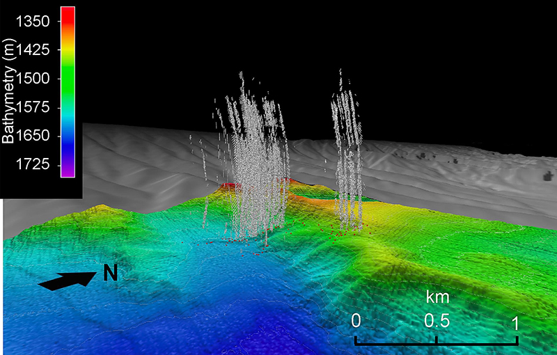
This 3D composite of water column data collected during an expedition on NOAA Ship Okeanos Explorer shows active seepage at the Norfolk seeps field. Red dots correspond to methane seeps, and the gray features show gas plumes as detected by the multibeam sonar. Image courtesy of Ruppel et al. 2024 . Download largest version (1.43 MB).
The updated seeps database released simultaneously with this research article adds hundreds of new seep identifications based on water column data collected between 2011 and 2016 and removes probable duplicates. Among the additional findings:
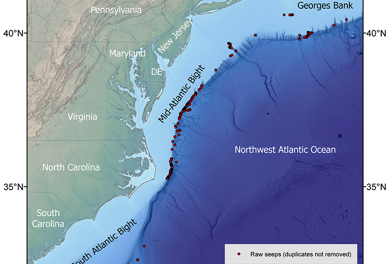
- Ninety-eight percent of the ~1,100 unique seep sites are between Cape Hatteras, North Carolina, and the southern New England margin.
- Spatial clustering analyses identify methane emissions in ~275 distinct areas, including 47 clusters with 5 to 138 discrete seeps.
- Most seeps are shallower than ~500 meters (1,640 feet) below sea level in the Mid-Atlantic Bight (Cape Hatteras to New York) and shallower than ~400 meters (1,312 feet) below sea level on the southern New England margin.

This map shows the distribution of methane seeps (shown as red circles) on the U.S. Atlantic Margin between the South Atlantic Bight and Georges Bank before removal of possible duplicates. It accompanies the database for the 2024 seeps study. Image courtesy of Carolyn Ruppel, U.S. Geological Survey. Download largest version (5.05 MB).
The new seeps database is publicly available through NOAA’s National Center for Environmental Information.
Study Importance
Methane seeps are important deep-ocean habitats, and methane emissions move carbon from the seafloor to the ocean, where it can be consumed by microbes. Methane is also a potent greenhouse gas, although most methane emitted at seeps is destroyed in the water column before it reaches the atmosphere.
The results of this study are a significant contribution to our understanding of seeps along the U.S. Atlantic Margin. Nevertheless, the authors note that seeps have not been fully mapped on all parts of the margin and that many seeps have yet to be explored (e.g., via remotely operated vehicle).

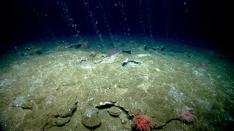
During a remotely operated vehicle dive offshore Virginia north of Washington Canyon, methane bubbles flow in small streams out of seafloor sediment. Quill worms, anemones, and patches of microbial mat can be seen in and along the periphery of the seepage area. This seep was discovered based on the analysis of water column data collected earlier in the expedition. Image courtesy of the NOAA Ocean Exploration, 2013 ROV Shakedown and Field Trials in the U.S. Atlantic Canyons. Download largest version (1.55 MB).
The new study was led by Carolyn Ruppel (USGS) and co-authored by Adam Skarke (Mississippi State University), along with other USGS scientists (Jared Kluesner, Nathan C. Miller, and Wayne Baldwin) and a former Mississippi State student (Maleen Kidiwela, now at University of Washington). It was sponsored by the U.S. Department of Energy, NOAA Ocean Exploration, the Bureau of Ocean Energy Management, and the National Academies of Sciences, Engineering, and Medicine.
Read the USGS news story | Access the full article online
Ruppel, C.D., A.D. Skarke, N.C. Miller, M.W. Kidiwela, J. Kluesner, and W. Baldwin. (2024). Methane Seeps on the U.S. Atlantic Margin: An Updated Inventory and Interpretative Framework. Marine Geology 471, 107287. https://doi.org/10.1016/j.margeo.2024.107287
Related Links
- Education Theme: Cold Seeps
- What is the difference between cold seeps and hydrothermal vents?
- Methane Bubbling Up From the Atlantic Seafloor. Who Knew?
- The 100th NOAA Ship Okeanos Explorer Mission Visits New Methane Plumes Where the U.S. Atlantic Seeps Story Began — Windows to the Deep 2019
- An Update on Cold Seeps in the Northwestern Atlantic Ocean — Windows to the Deep 2019
- Discoveries at a Methane Seep Field Offshore Bodie Island, North Carolina — Windows to the Deep 2019
- IMMeRSS — Interagency Mission for Methane Research on Seafloor Seeps
- Chemosynthetic Communities and Gas Hydrates at Cold Seeps South of Nantucket — Northeast Canyons 2013
Published May 8, 2024