June 14-27, 2021
From June 14 to 27, 2021, a multidisciplinary team carried out a remote sensing and diving survey to locate and characterize archaeological sites west of Key West, Florida, in an area within Florida Keys National Marine Sanctuary (FKNMS) known as the “Quicksands.”
Bordering the Straits of Florida and dividing the Gulf of Mexico from the Atlantic Ocean, the Quicksands are a significant navigational hazard for vessels transiting one of the busiest shipping routes in the Western Hemisphere. With its hidden shoals extending from the Marquesas Keys towards the Dry Tortugas and highly variable and potentially destructive weather, numerous shipwrecks have occurred over the 500 years of maritime traffic in the region. Although the Quicksands are situated within a national marine sanctuary, the area had not previously been systematically explored for its archaeological resources.
This 3D model, available on the University of Miami’s Underwater Archaeology Sketchfab website , shows the stern of what is believed to be a landing craft shipwreck located in the Quicksands area of Florida Keys National Marine Sanctuary. Image courtesy of the University of Miami. Download image (jpg, 500 KB).
The expedition team, made up of archaeologists and ecologists from the NOAA Office of National Marine Sanctuaries (ONMS) and the University of Miami’s Rosenstiel School of Marine and Atmospheric Science (RSMAS), surveyed portions of the project area on board the motor vessel Makai using high-frequency side-scan sonar and magnetometry. The team mapped six square kilometers of seafloor and recorded several dozen acoustic and magnetic targets which may be shipwrecks preserved under the area’s shifting sands. In addition to the remote sensing surveys, the project’s dive teams conducted focused investigations at reported shipwreck and archaeological site locations throughout the area. Several of these sites were documented with the University of Miami’s Integrated Benthic Imaging System (IBIS), resulting in high-resolution photogrammetric models that can be viewed on the University of Miami’s Underwater Archaeology Sketchfab website .
This 3D model of the northeast segment of the Valbanera shipwreck is available on the University of Miami’s Underwater Archaeology Sketchfab website . It is believed to display the vessel’s stern. The shipwreck is located in the Quicksands area of Florida Keys National Marine Sanctuary. Valbanera sank during a hurricane in September 1919. All 488 persons onboard perished. The location of the wreck was confirmed during the Florida Keys National Marine Sanctuary Quicksands Archaeological Survey expedition. Image courtesy of the University of Miami. Download image (jpg, 360 KB).
Through their exploratory expedition, the project team documented four shipwrecks of naval origin and two merchant sailing vessels. At each site, the team’s ecologists characterized the resident biological communities to assess these “human-made” hard bottom habitats. The team generated 3D models from collected data, including a model of the historically significant Valbanera shipwreck, a Spanish steamship that sank with all lives lost - some 488 people - in a 1919 hurricane while carrying emigrants from Spain to Cuba.

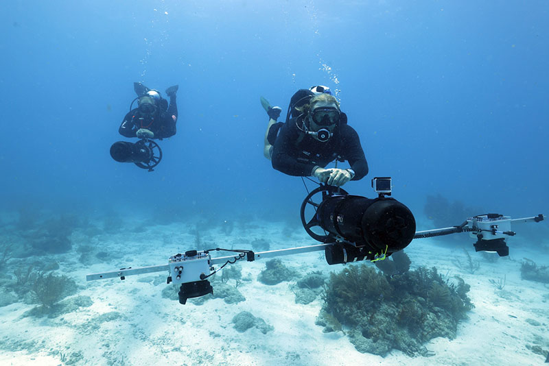
University of Miami archaeologist Fritz Hanselmann “flying” the IBIS camera system used for photogrammetric imaging during the Florida Keys National Marine Sanctuary Quicksands Archaeological Survey expedition. Image courtesy of NOAA and UM-RSMAS, Quicksands Archaeological Survey. Download image (jpg, 1.9 MB).

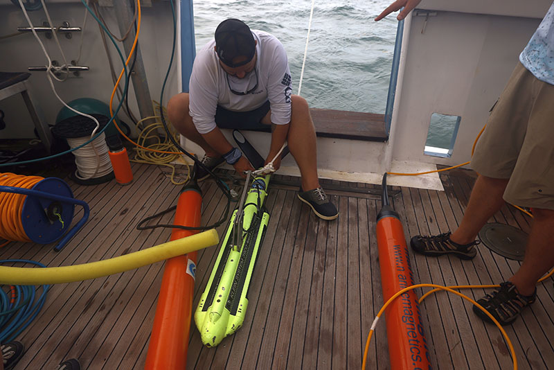
University of Miami student Ryan Fochs prepares the remote sensing equipment for launch during the Florida Keys National Marine Sanctuary Quicksands Archaeological Survey expedition. Image courtesy of NOAA and UM-RSMAS, Quicksands Archaeological Survey. Download image (jpg, 7.1 MB).
The expedition team confirmed Valbanera‘s location and characteristics. Their analysis of the archaeological site’s orientation suggested that the steamship’s captain tried to halt its storm-driven trajectory into the Quicksands by anchoring, but was not successful. The shipwreck is only a short distance away from deep water that would have let the steamship escape into the Gulf of Mexico.
Overall, the expedition’s findings have contributed to the delineation of Florida Keys National Marine Sanctuary’s maritime cultural landscape, which includes navigation aids and other structures associated with maritime use of the area. The expedition team anticipates that future projects will help groundtruth the remote sensing targets identified during the expedition. Numerous other reported archaeological sites in the Quicksands will also be the subject of similar investigations to reveal the little known chapters of Florida Keys’ history.