By Heather Coleman, NOAA Deep Sea Coral Research and Technology Program
August 19, 2017

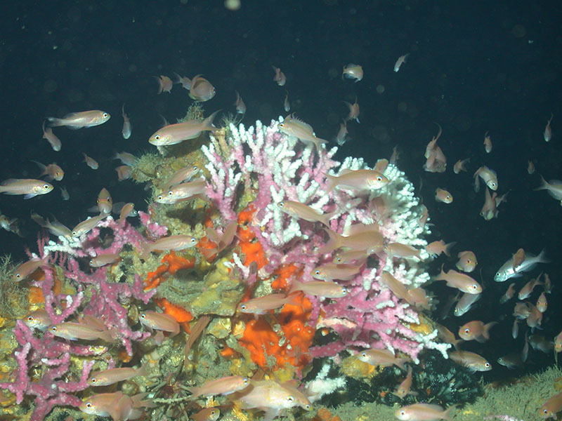
A deep-sea coral garden in Madison-Swanson Marine Reserve off the west coast of Florida, protected in 2000. Image courtesy of the National Undersea Research Center at the University of North Carolina, Wilmington. Download larger version (jpg, 2.1 MB).
If you have been following our expedition mission logs from NOAA Ship Nancy Foster, you know that we are striving to learn more about deep-sea coral genetic linkages and reproductive patterns. But did you also know that our mission aims to survey the seafloor to document where corals are found within areas currently considered for habitat protection in the Gulf of Mexico?
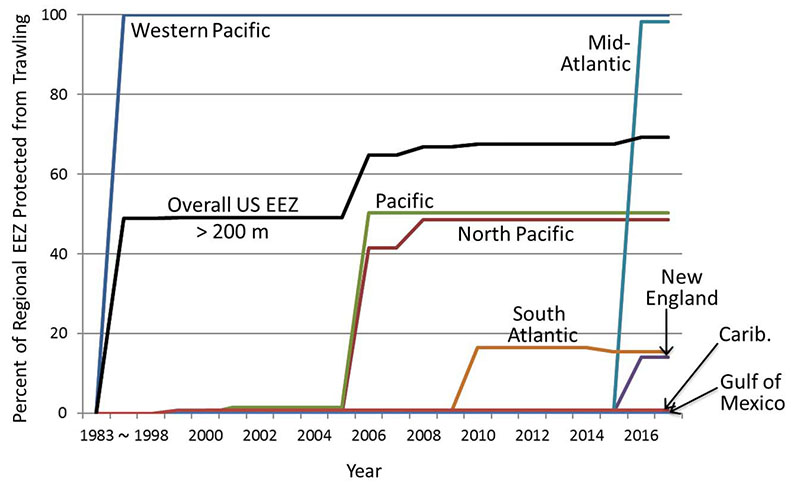
Researchers and managers have been working together to protect these vulnerable ecosystems for a long time – in fact, the story of deep-sea coral conservation goes back more than 30 years. Habitat protection in deep U.S. waters officially began in the early 1980s with fishing closures in relatively small but valuable coral-rich areas off eastern Florida known as Oculina Bank, and in Middle Grounds off west Florida. Around the same time, seafloor trawling was banned in the entire U.S. Pacific Islands territory (almost 50 percent of the country’s overall ocean area!). Twenty years later, large areas of deep west coast and Alaskan waters were protected as essential fish habitat as well. Avoiding damage from trawl fishing motivated some of these protections, as this activity can substantially threaten coral and sponge habitats.

Deep-sea coral and fish thrive in Madison-Swanson Marine Reserve off the west coast of Florida, protected in 2000. Image courtesy of the National Undersea Research Center at the University of North Carolina, Wilmington. Download larger version (jpg, 1.6 MB).
U.S. regional Fishery Management Councils determine where, when, and how fishing activities will be permitted within federal waters. By now, each Council has established its own deep-sea protected areas, and many have been closed to trawling for the purpose of conserving deep-sea coral and sponge habitat. Since these fragile and long-lived animals are extremely vulnerable, closing high-density coral areas to trawling can help maintain their function as habitat for commercially harvested fish and invertebrates. Recently, deep-sea coral focused expeditions in the Northeast U.S. led to substantial protections for these resources – most of the deep Mid-Atlantic seafloor was closed to trawling in January 2017 and a decision on how much deep water to protect in New England is expected later this year. See our interactive map for the rest of the story!
With less than one percent of the deep waters (> 200 meters) of the Gulf of Mexico currently closed to bottom trawling, our mission on the West Florida slope has prioritized areas where the Gulf of Mexico Fishery Management Council is considering new protections from fishing gear. We hope that the new coral and sponge location information provided by this expedition will help inform management decisions in the Gulf.

Graph showing the cumulative percent of each U.S. Fishery Management Council’s Exclusive Economic Zone (EEZ, which extends to 200 nautical miles offshore) deeper than 200 meters that has been protected from bottom trawling. The black line shows the overall percentage of area protected across all U.S. waters over time. Image courtesy of the NOAA Deep Sea Coral Research and Technology Program. Download larger version (jpg, 94.1 KB).
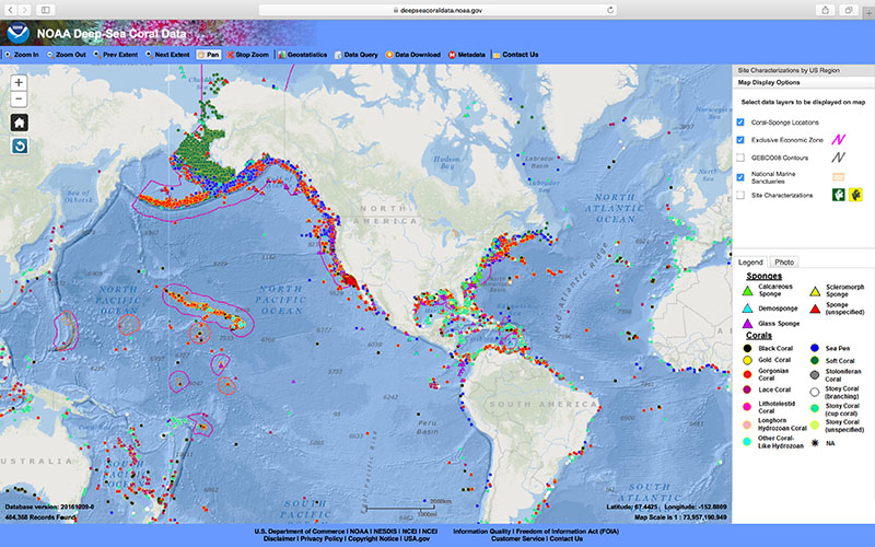
To see the national picture of where deep corals and sponges have been found so far, check out our data portal map. It is frequently updated with new findings that improve our understanding of deep-sea coral and sponge communities and inform decisions on how to manage these valuable and vulnerable marine resources.

The Deep Sea Coral Data Portal digital map showing known locations of corals (circles) and sponges (triangles). Coral and sponge location records are tagged with metadata and many have associates photographs available as well. Note that the map does not yet show areas in which researchers have searched and found no coral. Image courtesy of the NOAA Deep Sea Coral Research and Technology Program. Download larger version (jpg, 3.1 MB).
The expedition is supported by NOAA’s Deep Sea Coral Research and Technology Program through the Southeast Deep Coral Initiative (SEDCI), a multi-disciplinary effort that will study deep-sea coral ecosystems across the Southeast United States in 2016-2019.