John Bright, Maritime Archaeologist - Thunder Bay National Marine Sanctuary

Sonar data showing U-576 (left) and Bluefields (the lump to the right) as they currently rest on the seabed. Photo courtesy of NOAA. Download larger version (jpg, 93 KB).
In the area off Cape Hatteras, North Carolina, where U-576 attacked convoy KS-520, there is little to mark the location of a heated exchange of fire during a July afternoon in 1942. With a modern echo sounder, one might see the small blips produced by Bluefields' or U-576’s structure off the bottom. Yet, no land is in sight, no aircraft circle above, no merchant vessels are steaming in columns, and no escorts are racing around their perimeter on constant vigil against patrolling U-boats. The sloping seafloor and mixing Gulf Stream currents likewise leave little trace for the observer. An alternative means, beyond the naked eye, is necessary to capture all of these complex variables into useful visual tool—a visualization—which battlefield researchers can then use as a starting point for assessing the actions that took place.

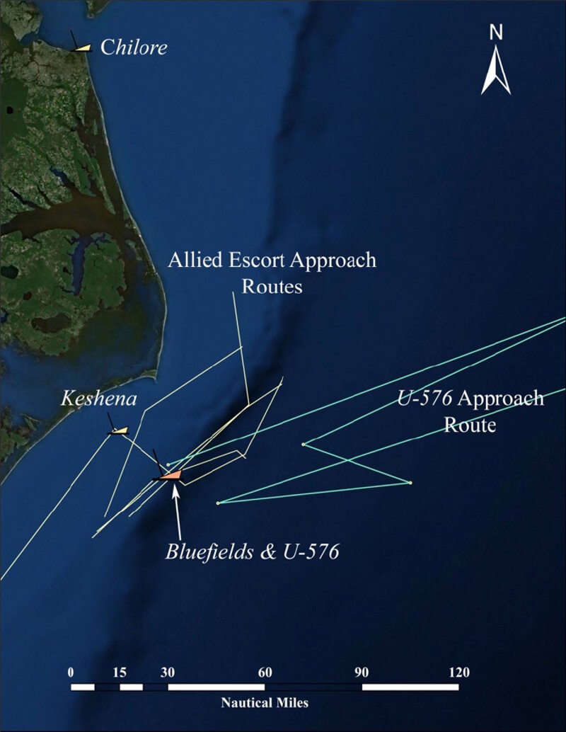
The KS-520 convoy attack area. The lines represent the historically reported ship positions. Photo courtesy of Bright 2012. Download image (jpg, 100 KB).
One of mediums through which this occurs is Geographic Information System (GIS) software, which is a digital means of integrating quantitative data with geographical locations. Static features of a landscape, such as coastlines, inlets, towns, and navigation buoys can be represented simultaneously with moving features, such as the location of ships in a convoy as they pass the coast.
Since GIS is geographical in its operation, distances can be measured and objects can be scaled to one another. The first step in re-creating the KS-520 convoy attack was to generate a scaled model of the convoy configuration based upon historical records. Each merchant ship’s relative size and position within the convoy was mapped out to be later included on a larger, regional map of the offshore North Carolina coastal area. Next, positions from each of the five escort vessels—USS McCormick, USS Ellis, USS Spry, and Coast Guard Cutters Icarus and Triton—were tabulated from their logbooks for the days before, during, after the convoy was attacked to define an area of travel off Cape Hatteras. Similarly, positions reported by U-576 to U-boat command were gathered from translated records captured at war’s end.
The relationship of the convoy escorts to the merchant vessel was determined by known patterns of escort coverage: the ships occupied pre-determined sectors around the main body of merchant ships as per anti-submarine protocols. Similarly, the position of U-576 relative to the convoy at the time of attack was triangulated by tracing back the pattern of torpedo strikes from the scaled convoy model, again using known tactical procedures. Aircraft circling above could see the convoy and beyond.
As U-576’s attack progressed, merchant vessels scattered and escorts sprang into action with depth charge attacks and rescue operations. J.A. Mowinckel and Chilore were damaged but afloat, Bluefields rapidly sank, but all of the crew escaped. U-576 was sent to the bottom by a combination of gunfire from merchant vessel Unicoi and the two aircraft providing coverage at the time. The action was far from over.
During rescue operations, communication errors between escort vessel USS Spry and merchant ship J.A. Mowinckle caused both ships, along with Chilore, to stray into the Hatteras Minefield. Again, both merchant ships suffered damage, this time at the hands of friendly mines. Subsequent rescue operations brought tugboat Keshena, under contract to the U.S. Navy, into the minefield where it was lost. Though both merchant vessels were patched up and sent back to Norfolk, Chilore sank under tow at the entrance to the Chesapeake Bay.
These GIS reconstructions proved invaluable tools for understanding the KS-520 battlefield. Not only did they help researchers retrace the minute-by-minute action of the battle, they also provided additional context in terms of landscape features and tactical factors that assisted in the assessment of certain critical decisions during the engagement and the physical location of the two vessels lost in the attack area: Bluefields and U-576.