By Robert V. Schwemmer, NOAA Office of National Marine Sanctuaries Maritime Heritage Program

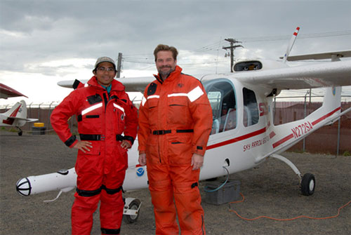
Pilot Rommel Zulueta, San Diego State University, and Robert Schwemmer, West Coast Regional Maritime Heritage Coordinator for NOAA Office of National Marine Sanctuaries, at the airport in Barrow preparing for Seahorse Islands flight in a Sky Arrow 650TCN survey aircraft. Image courtesy of Alice Drake/BASC. Download larger version (jpg, 161 KB).
In July 2007, I was in Alaska to conduct background research on the whaling fleets of the Western Arctic. During that visit, I had the opportunity to ride as a passenger in a small aircraft, to fly along the coast where we ultimately intended to conduct mapping operations. This was a unique and unexpected chance to get “the lay of the land” in the area where we were hoping to search for the "lost" whaling fleets.
With the ice pack 30 miles off shore that season, the aerial reconnaissance flight stretched from Point Franklin and Wainwright and offshore Seahorse Islands, covering around 45 miles of remote coastline. Historical documents report as many as 80 whaling ships were lost or abandoned in the 19th and early 20th century, many attributed to the lost whaling fleets of 1871 and 1876.
There are limited aerial platforms in the remote western North Slope Borough from which to conduct an aerial survey at lower air speeds, but it just so happened that San Diego State University’s Global Change Research Group (GCRG) was working in the region. Their Sky Arrow 650TCN survey airplane is based out of the airport at Barrow, Alaska, and is equipped with instruments for remote sensing to detect ecosystem carbon flux. It also flies very slowly.
The 2007 aerial reconnaissance flight was flown by scientist and skilled pilot Rommel Zulueta of GCRG. This aircraft has a clear bubble canopy down to your waist level over the cockpit, with the observer’s seat elevated above the pilot for forward viewing. The most important advantage of the Sky Arrow besides having the ability to fly at a slower air speed is that the side acrylic windows are removable for photography.

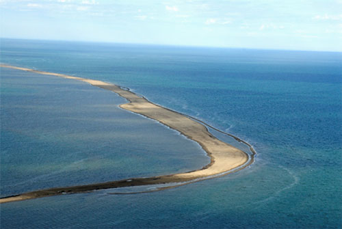
Approaching the Seahorse Islands from the southeast, the narrow islands are barren and sandy, providing some bird habitat in the summer months. The islands likely change shape and size through the winter months due to harsh arctic winds and ice pack movement. Image courtesy of Robert Schwemmer/NOAA. Download larger version (jpg, 162 KB).
With the narrow width of aircraft, slightly wider than the observer dressed out in a full Mustang floatation suit, there are few blind spots and complete access through the left and right windows of the aircraft. With the rear-mounted engine pusher propeller design, the photographer does not have to contend with air movement generated by the propeller.
We flew out of the airport at Barrow on July 18, 2007, and were met with clear skies, unlimited visibility. We banked the aircraft southwest and flew the coastline for 45 miles, observing fishing camps on the beach and miles of vast open tundra wilderness with endless small lakes off into the distance. Inflight, I removed the aircraft’s windows to prepare for our change in course northwest for the Seahorse Islands lying just offshore.
The Seahorse Islands are located off Peard Bay in the Chuckchi Sea, extending out to Point Franklin. From the air, the narrow islands are barren and sandy, providing some bird habitat in the summer months. Likely the islands change in shape and size by harsh Arctic-driven winds and ice pack flow. Shipwreck debris, if not covered over by sand, would easily be recognizable on the sand beaches.
During the flight, no wreckage was observed on the islands; the offshore water clarity was limited so it would be difficult to observe submerged wreckage.
After completing the aerial flyover of the islands, we headed southwest over Point Franklin towards the Wainwright airport where the aerial reconnaissance flight would be concluded. As we were approaching Atanik Point, inside Peard Bay near Point Franklin, we observed wreckage on the beach in Peard Bay, and it was recorded with still and video photography (Point Franklin shipwreck 001). Flying further southwest, a second observation of wreckage was noted in the surf zone (Point Franklin shipwreck 002), and the site was recorded from the air. GPS coordinates were recorded for both shipwreck sites.

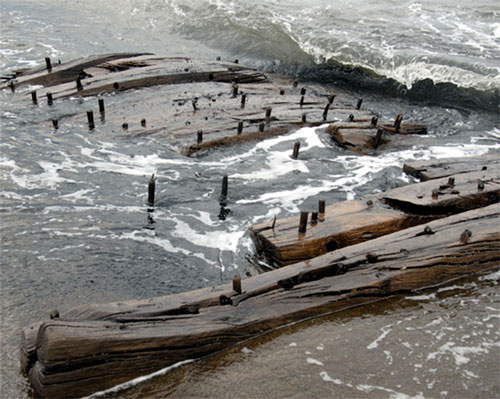
The shipwreck remains located off Point Franklin represent 19th century wooden ship construction. The wood frames are likely from the lower portion of the vessel near the turn of the bilge. The wooden pegs, seen here on a section of ship hull, are known as treenails and were used to fasten pieces of wood together, and in this case they were used to attach the exterior hull planking or interior ceiling planks. Image courtesy of Robert Schwemmer/NOAA. Download larger version (jpg, 266 KB).
After landing, I took a short boat ride from Wainwright to Point Franklin to visit the research encampment of the team lead by Randy Beebe and had the opportunity to survey the wreckage observed on the flight. The shipwreck remains discovered off Point Franklin region could be associated with vessels engaged in whaling or other commercial trades in the Arctic, but without whaling craft, the artifacts associated with commercial whaling, it's difficult to confirm they are whaling ships.
Most certainly whaling shipwrecks and their associated artifacts, such as large iron try-pots used to render (boil) the whale blubber, are still waiting to be discovered offshore and will offer clues to the region’s whaling seafaring past and larger maritime cultural landscape.
For more information on the aerial surveys, visit this page.