
By Joseph Resing, Chief Scientist - JISAO University of Washington, Seattle WA
and Bob Embley, Geophysicist - NOAA Vents Program, PMEL
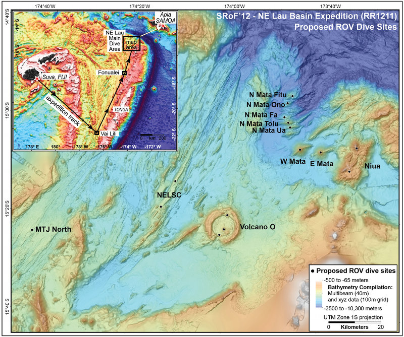
The inset in the top left shows the SRoF’12 - Northeast Lau Basin proposed remotely operated vehicle dive sites (black boxes), and expedition track (arrows). The main map area shows the possible dive sites (black dots) at major features of interest including the North Matas, West and East Mata, Niua, Volcano O, Northeast Lau Spreading Center (NELSC), and the Mangatolu Triple Junction (MTJ) North. Image courtesy of NOAA Vents Program. Download larger version (jpg, 4.7 MB).
The Submarine Ring of Fire 2012 - Northeast Lau Basin expedition on the research vessel (R/V) Roger Revelle will depart September 9 from Suva, Fiji, and arrive September 26 in Apia, Samoa. The region of exploration is the Northeast Lau Basin, zone where ocean plates both come together and separate at the highest rates on the planet. Our preliminary surveys between 2008 and 2011 revealed that the NE Lau is home to one of the most concentrated areas of active submarine volcanism and hot springs found anywhere on Earth (see below). The initial cruise in 2008 discovered two sites of ongoing seafloor eruptions using remote detection by towing sensors collecting water samples (known as a CTD-hydrocast). The observations were so rare, that we returned less than 6 months later in 2009 with a group of NSF and NOAA funded scientists to verify and sample the eruption sites using a tethered robot known as a remotely operated vehicle. Several other expeditions to the area in 2010 and 2011 continued the remote exploration with hydrocasting to collect sea water and dredging of the sea bottom to collect rocks, combined with a towed camera system to image the bottom and a completely autonomous vehicle to make high resolution maps of the volcanoes and their hot springs.
The intense volcanic and hydrothermal activity in the Northeast Lau Basin was so stunning that during our initial surveys in 2008 and 2010 it always seemed that the next hydrocasts would (and often did!) reveal yet another volcanic eruption or site of intense hydrothermal activity. This area is particularly exciting because of the wide range of geology and depth of the active sites. In past explorations of the volcanic arcs of the Mariana and Kermadec subduction zones we concentrated on the “magmatic“ arc. The arc is the line of volcanoes including islands that form along and above the trench. When one ocean plate goes down beneath another (subduction), the down-going plate is heated. The heat drives off water which migrates upward. As the water mixes with the mantle rocks above it, those rocks melt. The magma collects in shallow magma “chambers“ that subsequently feed eruptions and over time construct volcanoes. These volcanoes form along the line of subduction, thus forming arcs or linear chains of volcanoes such as we see in the Mariana arc north of Guam and in the Cascade volcanoes of the U.S. Pacific Northwest. As you travel from the trench over the arc and continue beyond you arrive at a zone called the “backarc.“ Here the plates spread apart due to extensional stresses associated with the interaction between the subducting and overriding plates. This process has formed the well-defined Northeast Lau spreading center (NELSC), where an eruption occurred in 2008. However, the Northeast Lau Basin is very unusual because it appears that much of the area between the back arc spreading center and the arc (represented by Niua volcano on the map) is also pulling apart and this area of extension is also rich in volcanic and hydrothermal activity. The volcanoes in this region include Volcano “O“, West Mata, East Mata, and the group of seven smaller elongated volcanoes referred to collectively as the North Matas. This area may be particularly “hot“ because it is at the termination of the subduction zone, where it bends to the west there seems to be a “tear“ in the Pacific plate; the northern part of the plate continues to the west while the southern part is subducted. The forces and stresses associated with the tear may allow more magma to form and to migrate to the surface than in other rear-arc areas.
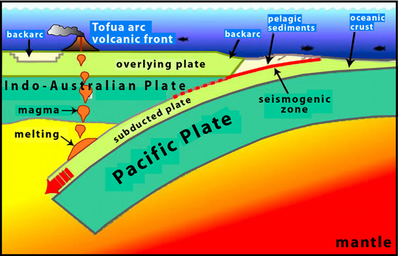
This illustration shows the Pacific plate in the east colliding with the Indo-Australian plate in the west. A consequence of this collision is subduction with the down going slab comprised of oceanic crust, or lithosphere, and a thin veneer of pelagic sediment. This causes extension behind the subduction zone, which is represented by backarc basins forming behind the arc front. At certain depths, usually around 200 kilometers (~100 nautical miles), there is melting of the subducted materials. The melting produces magmas that rise buoyantly to pond in the overlying mantle wedge and periodically erupt on Earth's surface as lavas, forming arc volcanoes. Image courtesy of GNS Science. Download larger version (jpg, 932 KB).
This cruise is the latest in a series of expeditions to explore the submarine volcanoes of the Western Pacific. It will be the first broad scale exploration of this portion of the Submarine Ring of Fire using a remotely operated vehicle. The interdisciplinary team of 27 scientists and technical experts from the United States, New Zealand and Australia will work closely with a team from the MARUM Center for Marine Environmental Sciences from the University of Bremen (Federal Republic of Germany) to utilize the remotely operated vehicle Quest 4000 to explore and collect samples at volcanic vents and hot springs. Our primary objective will be to explore and to characterize the unique ecosystems in the Northeast Lau Basin through examination of their geology, chemistry, and macro- and micro- biology. The Quest 4000 will collect samples of fauna and microbes, volcanic rocks, hot fluids and gases, and minerals formed at the vents. These observations and collections will increase our understanding of this dynamic environment and potentially lead to exciting new discoveries. The expedition will also revisit the site of the world’s deepest active submarine eruption discovered in 2009. Since our visit in 2009, a hydrophone has been recording sounds of the eruption. When we recover this instrument it will provide a record of the intensity and duration of the eruption. It may also help us understand dramatic changes in the volcano’s summit revealed in a seafloor map made in 2011.
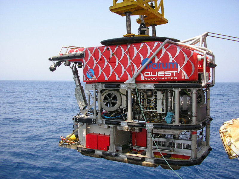
The Quest 4000 remotely operated vehicle will be utilized on the SRoF’12 – NE Lau expedition, providing high-definition video and seafloor sampling capabilities. Image courtesy of MARUM. Download larger version (jpg, 1.6 MB).
After mobilizing the Quest 4000 on the R/V Roger Revelle in Suva, Fiji, we will traverse to the Lau basin to begin our dives at the Vai Lili vent along the Valu Fa Ridge (VFR), the easternmost of the Lau spreading centers, to collect samples of microbial mats. This site is a primary target of the group led by Brad Tebo (NSF funded portion of the expedition) because of its unusual microbial mats composed of iron and manganese metabolizing bacteria that will be sampled by the ROV using a specialized scoop device. We will then proceed north to conduct dives at the Fonualei Rift (a spreading center to the north of Valu Fa), Niua volcano, the Mata volcanoes (which includes the West Mata eruption site) and Volcano O.
When the ROV is not in the water we will explore for new hydrothermal sites using CTD-hydrocasts, re-map the volcanoes with the ship’s multibeam sonar system to looking for changes at the active volcanoes, and use the ship’s Acoustic Doppler Current Profiler and Hydrographic Doppler sonar systems to measure regional and local deep currents around the volcanoes. We will also examine the magnetic structure of Volcano O, which is dominated by one of the Earth’s largest submarine calderas (large craters formed from the collapse of the volcano’s summit following an eruption or eruptions).
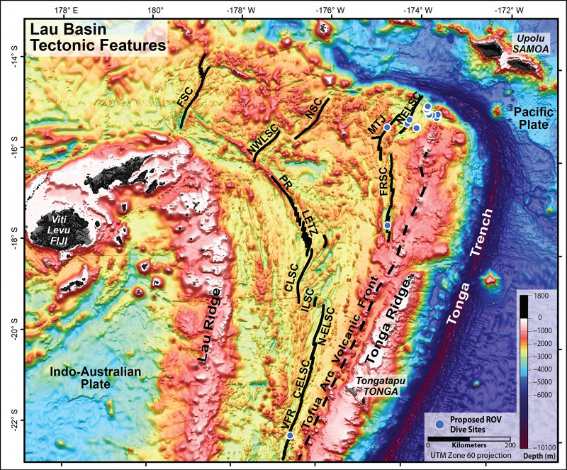
Tectonic features of the Lau Basin overlaid on satellite altimetry data, modified from Martinez and Taylor Geophysical Monograph 166, 2006. The Spreading centers and ridges are shown with black solid lines: Valu Fa Ridge (VFR), Central Eastern Lau Spreading Center (C-ELSC), Intermediate Lau Spreading Center (ILSC), Central Lau Spreading Center (CLSC), Lau Extensional Transform Zone (LETZ), Peggy Ridge (PR), North-West Lau Spreading Center (NWLSC), Niuafo’ou Spreading Center (NSC), Futuna Spreading Center (FSC), Mangatolu Triple Junction (MTJ), Fonualei Rift and Spreading Center (FRSC), North-East Lau Spreading Center (NELSC). Tonga trench, ridges and tectonic plates are also noted. Image courtesy of NOAA Vents Program. Download larger version (jpg, 4.9 MB).
Our preliminary data promise that each of these sites will yield important new and exciting discoveries. On the day before the first dive at a site, we will tell you in more detail what we know about that area to provide a context for the coming exploration with the Quest 4000. During the dive, seafloor video imagery will be transmitted back to shore using an enhanced satellite link so that the global community can share in these exciting explorations in real time. We hope you will join us as we continue our explorations of the Submarine Ring of Fire at the Northeast Lau Basin to explore the wonders of one of the Earth's great hidden landscapes.
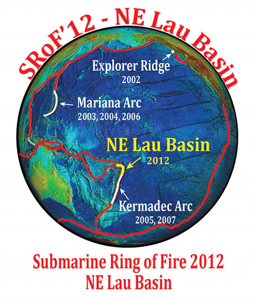
Join scientists in the latest in a series of expeditions to explore the submarine volcanoes of the Western Pacific. See the highlights, including daily logs, images and video. Image courtesy of Submarine Ring of Fire 2012: Northeast Lau Basin, NOAA-OER. Download larger version (jpg, 1.3 MB).