
By Thomas M. Iliffe, PhD, Expedition Principal Investigator Director, Marine Biospeleology Lab - Texas A&M University – Galveston
June 7 - 27, 2011
The goal of the “Bermuda Deep Water Caves 2011: Dives of Discovery” expedition is to explore and characterize the upper edge of the Bermuda Platform and an adjacent mid-ocean seamount to confirm the existence of deep-water (60-200 meter/197-656 foot depth) caves. The initial two phases of this project were conducted in 2009. First, in collaboration with Dr. Rikk Kvitek of California State University’s Seafloor Mapping Lab, high resolution multibeam sonar was used to produce detailed, geo-referenced maps of the shelf edge of the Bermuda Platform and adjacent Challenger Bank.
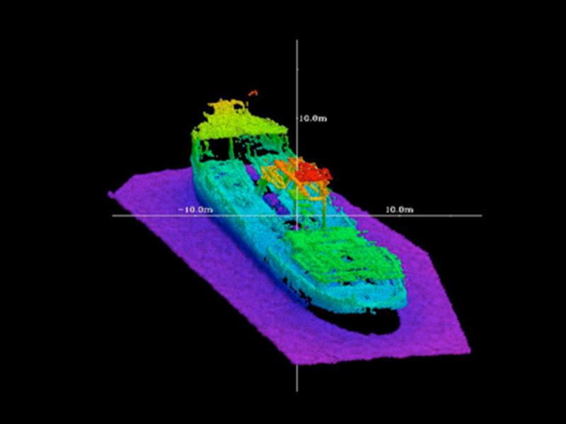
Multibeam bathymetric image of the King George shipwreck in Bermuda color coded with depth such that the warmer colors (red, orange, etc.) represent shallower depths, while the colder colors (purple) correspond to deeper depths. This dredge ship was intentionally sunk in 18 m water depths of the north lagoon in 1930. Image courtesy of Rikk Kvitek, Bermuda Deep Water Caves 2011 Exploration, NOAA-OER. Download larger version (jpg, 902 KB).
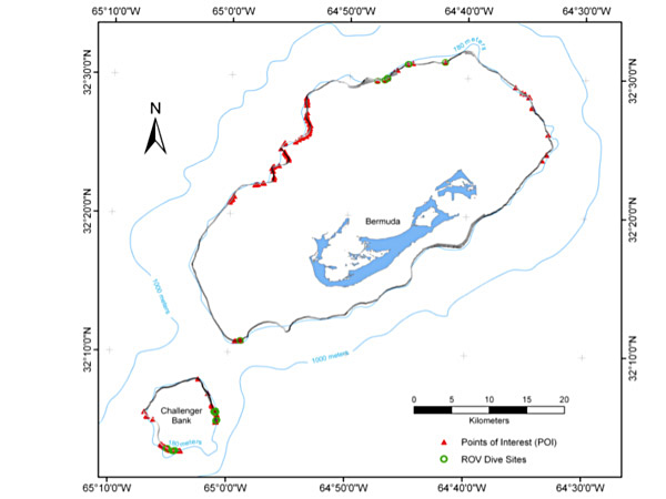
Multibeam map of the shelf edge of the Bermuda Platform and Challenger Bank overlaid on top of the nautical chart of the island. Points of Interest, indicating potential cave entrances, are marked by red triangles, while ROV dive sites are indicated by green circles. Contour lines are from current nautical charts. Note that the 180 m contour derived from nautical charts (light blue line) varies considerably in some locations from our more precisely mapped position (darker line). Image courtesy of Rikk Kvitek, Bermuda Deep Water Caves 2011 Exploration, NOAA-OER. Download larger version (jpg, 905 KB).
During the initial calibration of the multibeam, the wreck of the dredge ship King George was mapped in order to test the equipment (Fig. 1). This ship was intentionally sunk in 1930 and lies upright on the bottom in 18 m water depths of the North Lagoon. More than 180 kilometers (112 miles) of sea floor around the 100 m contour (including ~60-200 m depths) were mapped around the entire perimeter of the main Bermuda Platform and ¾ of the Challenger Bank (Fig. 2). The aim of the mapping was to locate potential deep water caves sites by examining multibeam profiles of the sea bottom to find consistent gaps in the data record which could indicate a void (Fig. 3). Numerous potential caves sites including 161 “points of interest” or potential cave locations were located by examining multibeam profiles of the sea bottom. These points of interest were primarily located at northwest, north, east and southwest sides of the main platform and on the southern and eastern margins of Challenger Bank. They included enclosed karstic sinkholes, numerous ledges, overhangs, possible cave entrances, and near vertical submarine cliff faces between ~80-160 m depths with vertical gullies, sand-floored ledges and landslides. The heads of several submarine landslides were discovered around the perimeter of the Bermuda shelf break suggestive of significant mass wasting activity down the flanks of the seamount (Fig. 4).
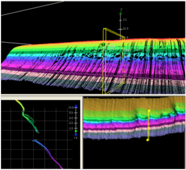
Challenger Bank as seen in CARIS subset mode showing point cloud data in 3D mode, profile and plan views. Note deeply incised overhang with undercut floor in profile view (lower left) suggestive of a cave entrance. Profile slice is only a few meters across. This opening is 7 m tall. Also note numerous “voids” or dark holes without data in the 3D point cloud view of the slope in the top frame. Each of these features were inspected, measured and catalogued as potential candidates for ROV dive targets. Image courtesy of Rikk Kvitek, Bermuda Deep Water Caves 2011 Exploration, NOAA-OER. Download larger version (jpg, 774 KB).
The second phase of this research involved of the use of an ROV (Remotely Operated Vehicle) to conduct dives on potential deep-water caves. During six days of ROV dives, 25 of the highest potential POI’s were explored during 33 ROV dives totaling 25 cumulative hours. Seven of the POIs investigated with the ROV, including four on southwestern edge of the main platform and three on the eastern side of Challenger Bank, were found to have possible caves extending back from them. The caves were relatively small, about a meter or less in diameter, tubular, and smooth walled with little encrusting marine life or other clear evidence of water currents such as sand ripples. These caves were typically found at the base of the undercuts and consisted of small tunnels extending perpendicular to the rock face. Caves on the main platform were found at 107, 112, 116 and 118 m water depths, while those on Challenger Bank were at 119, 123 and 128 m.
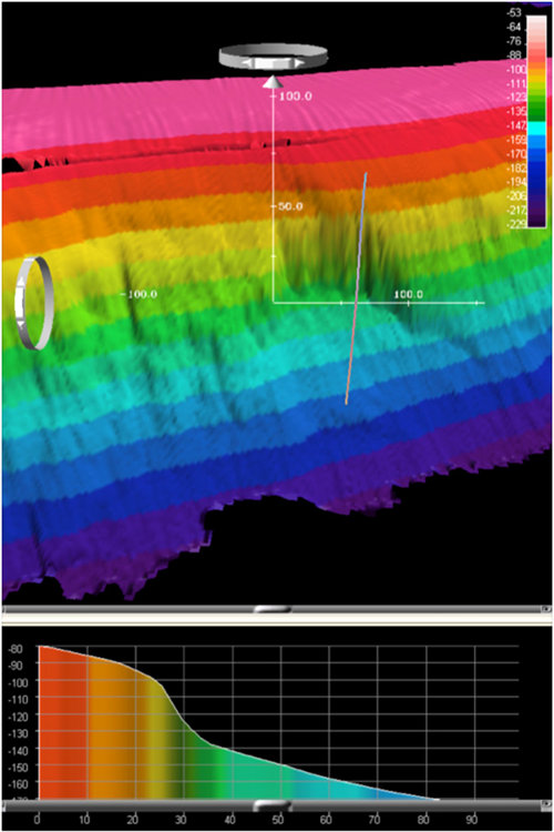
Multibeam bathymetry data gridded at 2m cell size of a submarine landslide escarpment discovered on the eastern edge of the Challenger Bank platform rendered in 3D shaded relief, colored by depth in (top), and in profile (bottom) using IVS Fledermaus software. Position and extent of the profile across the escarpment face is indicated by the polyline in the upper image. All dimensions are in meters. Image courtesy of Rikk Kvitek, Bermuda Deep Water Caves 2011 Exploration, NOAA-OER. Download larger version (jpg, 2.1 MB).
On the northern edge of the platform, several completely closed depressions, resembling karstic sinkholes were found near the seaward margin of the lower terrace. These were approximately 20-30 m in diameter and 3-5 m deep with steep, sometimes undercut rock walls on all sides and a relatively flat floored bottom. In this same area, a number of sediment floor channels with steeper rock walls and branching patterns ran perpendicular to the platform edge. In one of these channels, the multibeam showed two voids (Fig. 5) that were later investigated with the ROV. This feature turned out to be a natural bridge, likely a remnant cave structure, about 40 m long and 8 m wide, with a 6 m high tunnel extending between the entrances. Boulders and rubble of apparent collapse origin were present at the landward end of this tunnel, while the seaward entrance was unobstructed. A sand-floored channel extended in both directions from the natural bridge suggesting that this structure represents the last remaining remnant of a much larger cave system that probably carried freshwater runoff to the platform edge at the time when the lower terrace was forming.
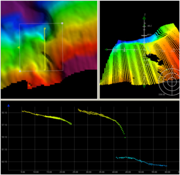
Multibeam bathymetry data from the natural bridge (POI 67) located on the outer terrace at 64 m depth near North Rock, displayed and colored by depth in CARIS software subset mode. Images of tunnel clockwise from top left: 1) Plan view of 2m gridded surface model in shaded relief shows the adjacent sand channel and sinkhole features with the position of the vertical profile referenced below seen as the yellow line, 2) down slope view of 3D sounding point cloud showing the upper tunnel entrance, 3) vertical profile slice through the point cloud at the position of the yellow line in view #1 showing both the inshore and offshore entrances of the tunnel. Vertical and horizontal scales are in meters. Image courtesy of Rikk Kvitek, Bermuda Deep Water Caves 2011 Exploration, NOAA-OER. Download larger version (jpg, 1.1 MB).
The third and final phase of the research will be conducted during June of 2011 and will consist of mixed gas, closed circuit rebreather dives to investigate prominent POIs. Due to the depth of these dives, helium is added the diver’s breathing mixtures to reduce the amounts of nitrogen and oxygen which can be narcotic or toxic at these pressures. Closed circuit systems recycle the diver’s breathing gas and thus conserve gas on deep dives. Our deep diving team will consist of four world-class cave and deep divers. In addition, support divers will bring additional tanks to the deep divers, transport collected samples to the surface, keep an eye out for sharks, and act as needed in case of any problems or emergency.
Dive sites will include the natural bridge (64 m depth), the edge of the wall off North Rock (91 m), and a potential cave at edge of Challenger Bank (122 m). At each of these dive sites, both biological and geological collections will be conducted. Biological collections include rock and rubble with attached organisms (algae, hydroids, sponges, bivalves), mobile organisms (hermit crabs, other crustaceans, gastropods, echinoderms, large worms), and attached macrofauna (corals, anemones, soft corals, bivalves, sponges). Highly mobile species will be recorded on descent, on bottom and on ascent via video, while patterns of abundance and diversity of benthic species will be recorded using video transects.
We will also examine deep water caves and the rock surrounding them. Any deep water caves will be evaluated for water flow and for preferred presence of sponges and other filter feeding organisms. If water flow is detected, an electronic water quality monitor will be placed in the cave entrance for 24 hours to determine the source and periodicity of water flow in relation to tidal cycles. Geological collections will be aimed at identifying and dating the occurrence of sea level low stands which took place during the maximum extent of Ice Age glaciation. Such evidence includes wave cut notches and drowned reefs that may help to characterize the extremes of climate and sea level. We will also collect samples of the bedrock to identify the depth of the contact zone between limestone and volcanic rock. One goal of the dives will be to become the first to actually reach and physically touch the volcanic rock underlying all of Bermuda.