By: Christopher German - Woods Hole Oceanographic Institution
The deep ocean is a vast and mostly unexplored system. It is also the largest, single, contiguous (joined together, without a break) habitat for life on our planet. If it is that big, then it is almost certainly also important in terms of how our home planet functions, as a whole, to sustain life — including us. So if we want to look after the Earth, then scientists must obtain the best information possible about the deep ocean. Why the deep ocean, specifically? Well, most people have heard that nearly two-thirds of the Earth is covered in water. But did you know that more than half of our planet is covered in seawater to a depth of more than 3,000 meters (9,842 feet)? That’s 3.2 kilometers — nearly two miles! — from top to bottom.
This animation shows how ABE is used to find and then photograph sites of hydrothermal activity. For more information see https://www.whoi.edu/multimedia/v-abe-animation/ . Download (mp4, 10.8 MB).
Ocean exploration is a very new field of science — just like space exploration. It is a field that continuously changes our understanding of the way Earth works. It was only about a hundred years ago that the first work was begun to investigate the oceans scientifically. When it comes to deep-sea research, we didn’t even have a good way to map the seafloor in detail until halfway through the 20th century, and it was only in 1964 that the deep submergence vehicle (DSV) Alvin was launched. This was the first machine that allowed American scientists to dive to the deep, ocean floor. In the following decades a number of manned and robotic submersibles have followed — and Alvin remains in active service, too — providing U.S. and international scientists access to the deep seafloor.
Alvin made one of the top ten discoveries of the last century: the existence of life, in the absence of sunlight at hydrothermal vents and cold seeps, at the bottom of the ocean. We previously thought of the deep ocean as just deep, dark, and cold. Today we continue to explore for more vent and seep sites around the world, because over the past 30 years we have found more than 600 species new to science. That translates to a rate of one new species every two weeks on average; or, more accurately, several new species every time we look somewhere new.
But the deep-ocean areas of the Earth’s surface waiting to be investigated remain vast, and the distances that any of our machines can cover in any given workday are small, because it is pitch dark. The only light to see by comes from the high-intensity lamps we carry. Even so, these penetrate no more than 3 meters (10 feet) or so ahead of us or to either side.
This reality presents ocean explorers with two key challenges. If we can explore only small parts of the ocean at any one time then we need to pick the places we choose to study very carefully so we can learn as much as possible from each expedition. We also want to use the cleverest methods possible for all of our exploration.
On this particular project, we are using towed instruments, an autonomous underwater vehicle (a free-swimming robot), and a video-guided seafloor sampling device to explore the Chile triple junction. This is one of the only places on Earth where a mid-ocean ridge (the kind of volcanic chain where hot lava spews out from the Earth’s interior at the floor of the ocean to form young ocean crust) is being swallowed, just as fast as it is produced, back into the underlying mantle along a so-called “subduction zone” at the bottom of the Peru-Chile trench.
We hope to find special animals here. These are animals that live where the active fluid flow from the seabed brings up all kinds of weird and wonderful chemicals from beneath the seafloor and into the deep ocean, where they provide important supplies of energy for life. (You can read more about the setting that we are exploring and the kinds of animals we want to locate.)
So how do we find these systems? We are on a research ship at the ocean's surface; that's some 3.2 kilometers (2 miles) above the seafloor. The systems are about the size of a football field. How do we do that? The answer is in the chemicals. Both hot vents and cold seeps release chemicals into the deep ocean that are not typically found there. Things like the dissolved metals iron and manganese and — most important for this expedition — methane.
When fluids from cold seeps or vents release these chemicals into the water column they do not last forever. Instead, they react with the dissolved oxygen in the ocean and, in the case of iron or manganese, they form particles of metal oxide (a bit like natural rust) that will eventually sink to the seabed. At the time they form, however, they generate lenses of smoky water just above the seafloor in the otherwise crystal-clear waters of the very deep ocean. For methane, the reaction is quite different. That compound simply combines with the oxygen in the ocean to produce dissolved carbon-dioxide and water. Since those reactions don’t take place instantly, we can tell when we are close to a venting site if we can measure chemical anomalies (something different from the background) in the water column.
First, for example, we can tow light-scattering sensors through the water to prospect for anomalously particle-rich water, which is often a first sign that a hot vent is nearby. Next, we take samples of seawater throughout these deep regions and measure them on board for dissolved methane. If we cannot measure anything, then we know we’re not very close. But the higher the concentrations get, the closer we are to the vent or seep. We know that hydrothermal vents show up about once every 100 km (62 miles) along all ridge-axes, so that’s the total length of ridge we’ve chosen to explore.

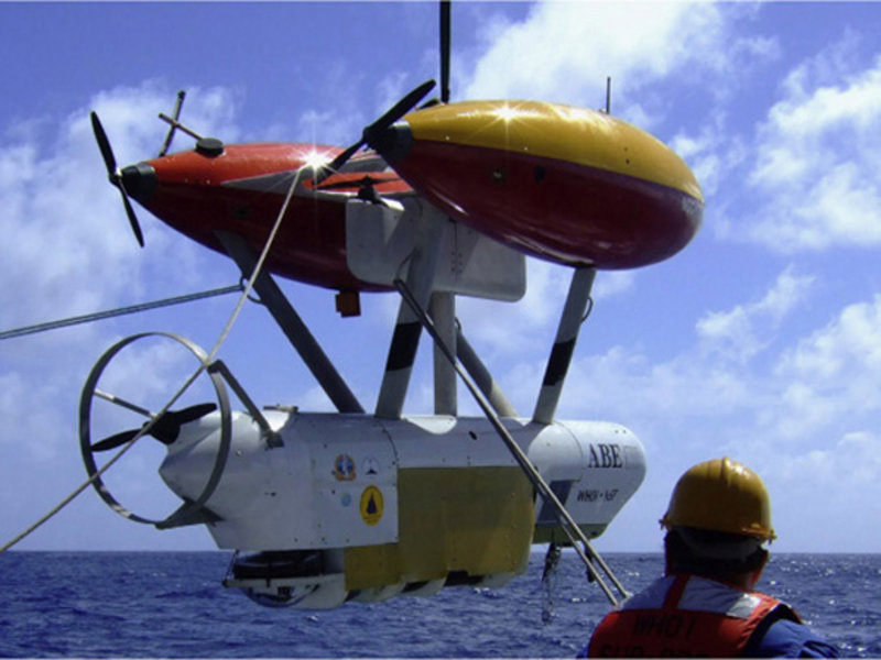
Figure 1. The autonomous benthic explorer (ABE) a free-swimming robot. In this image, ABE is about to be set loose to explore the bottom of the SW Indian Ocean from aboard the Chinese research ship Da Yang Yi Hao in 2007. Over the past five years, ABE has been used on multiple expeditions to find new hydrothermal vents in the deep ocean all over the world, from New Zealand to South Africa and Brazil to Ecuador. Image courtesy of Christopher German. Download image (jpg, 87 KB).
When we think we are getting close, it will be time to use our “secret weapon": ABE (autonomous benthic explorer). This is not the first time we have used ABE for NOAA’s Ocean Exploration program. Over the past five years, we have used our techniques to track down 15 to 20 vent-sites, all over the world’s oceans, working with co-explorers from England, Germany, and China. However, this is our first chance to operate so far down the coast of South America — and we’re excited!
ABE is an unmanned robot. Once it starts a mission, it cannot do anything that it hasn’t already been "told" to do. It follows instructions from a computer program that our engineers write and upload to the vehicle before the mission begins. After that, we lift ABE up on a crane and lower it off the side of the ship into the water (figure 1). Then we sit back, let ABE run its mission the way we programmed it, and wait for it to come back to the sea-surface, where we can fish it back aboard ship, download its data to computers, and begin to interpret the results.
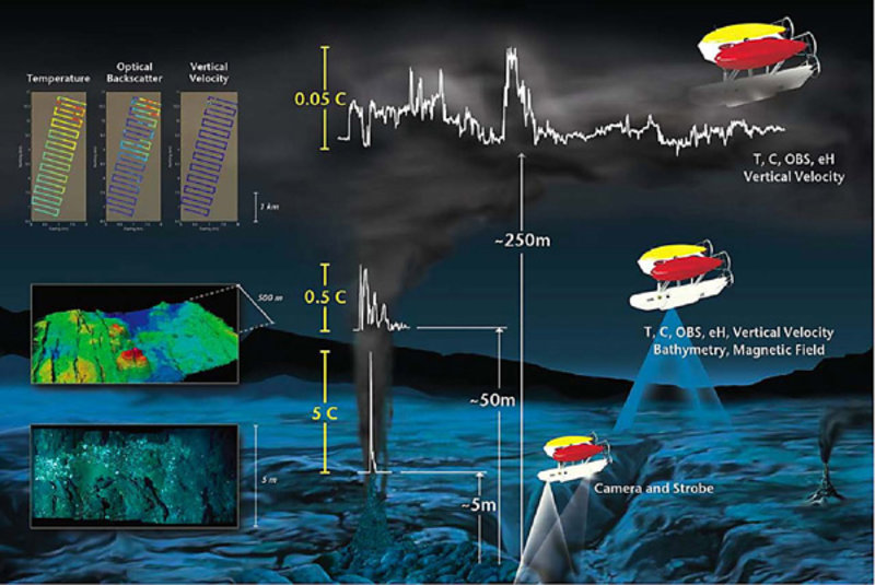
In other words, we have to be very clever — and very careful — about what we program ABE to do. Here’s the three-phase scheme we’ve developed over the past few years that we have found works (figure 2). First, we program ABE to dive down to whatever depth the strongest chemical plumes occur at and swim back and forth in a regular pattern that we call “mowing the lawn” to map out exactly where the strongest chemical signals are located. We do this by using chemical sensors mounted on ABE that measure the strengths of the signals in the water. However, it is only when ABE comes back on deck that we can analyze the resulting data and find out where ABE’s closest point of approach was. Typically, ABE maps out an area about 5 km (3 miles) on a side during Phase I work.
Next, comes Phase II. If we assume that the highest chemical signals are found above the source of their release from the seafloor, then we can take the core of the plumes mapped out by ABE in Phase I and program the autonomous underwater vehicle to dive back to that location. There ABE can make a detailed map of the seafloor, typically about 1 to 2 km on a side (about 1 square mile), by flying back and forth along more closely spaced lines to generate a map using sonar.
Finally, we are ready for the “end game” — Phase III — in which ABE is programmed to head back to the seafloor and, based on both the chemical data we have collected (Phase I) and the detailed maps we have now made (Phase II), we program ABE to fly close above the seafloor (typically just 5 m, or 16 ft, above what can be rough and rocky terrain), to take downward-looking photographs of the seafloor, including any vents or seeps that are present and any unusual animals that live there, fueled by the vents or seeps.
Ocean exploration is fascinating and exciting. To do it well you need to identify some really important scientific questions that need answering to help get you started, and some very clever technology (and technologists) to help you get the job done.

Figure 2. This artist's rendition shows the three-phased approach to ocean exploration with ABE. Image courtesy of Christopher German. Download image (jpg, 101 KB).